


Avery Tomasco
@averytomascowx.bsky.social
I'm here because I lost a bet. Follow me for occasionally unhinged forecast content for Central Texas
Fresh augmented reality update on our overnight storm chance.
Severe weather = bad. Flood threat = ...Good? Yeah, good if we all stay smart.
Severe weather = bad. Flood threat = ...Good? Yeah, good if we all stay smart.
June 4, 2025 at 3:17 AM
Fresh augmented reality update on our overnight storm chance.
Severe weather = bad. Flood threat = ...Good? Yeah, good if we all stay smart.
Severe weather = bad. Flood threat = ...Good? Yeah, good if we all stay smart.
Ain't nothin' like last week, but keep your eyes peeled for severe storms LATE tonight (after midnight) primarily to the northwest of Austin.
Level 2/5 risk for hail, winds, and a quick tornado. Slow-moving storms could also produce flash flooding
Level 2/5 risk for hail, winds, and a quick tornado. Slow-moving storms could also produce flash flooding

June 3, 2025 at 9:19 PM
Ain't nothin' like last week, but keep your eyes peeled for severe storms LATE tonight (after midnight) primarily to the northwest of Austin.
Level 2/5 risk for hail, winds, and a quick tornado. Slow-moving storms could also produce flash flooding
Level 2/5 risk for hail, winds, and a quick tornado. Slow-moving storms could also produce flash flooding
SWEET SWEET VICTORY
2.31" in Austin yesterday was the biggest one-day rain total in more than a year
2.31" in Austin yesterday was the biggest one-day rain total in more than a year

May 27, 2025 at 12:03 PM
SWEET SWEET VICTORY
2.31" in Austin yesterday was the biggest one-day rain total in more than a year
2.31" in Austin yesterday was the biggest one-day rain total in more than a year
No sorry I got logged out for a while but finally got this back up and running.
I've sinned and will atone with new updates here I promise
I've sinned and will atone with new updates here I promise

@averytomascowx.bsky.social did you abandon us
May 27, 2025 at 12:00 PM
No sorry I got logged out for a while but finally got this back up and running.
I've sinned and will atone with new updates here I promise
I've sinned and will atone with new updates here I promise
The third and final day of severe weather this week is poised to be the most widespread & significant.
Level 3 out of 5 risk in Austin for the first time in nearly a year. Storms quickly turn severe after 12 PM today with very large hail, damaging winds, and an isolated tornado possible
Level 3 out of 5 risk in Austin for the first time in nearly a year. Storms quickly turn severe after 12 PM today with very large hail, damaging winds, and an isolated tornado possible

May 2, 2025 at 11:39 AM
The third and final day of severe weather this week is poised to be the most widespread & significant.
Level 3 out of 5 risk in Austin for the first time in nearly a year. Storms quickly turn severe after 12 PM today with very large hail, damaging winds, and an isolated tornado possible
Level 3 out of 5 risk in Austin for the first time in nearly a year. Storms quickly turn severe after 12 PM today with very large hail, damaging winds, and an isolated tornado possible
WEATHER ALERT DAY - Severe storms are likely for more of us Thursday afternoon->evening.
Level 1 out of 5 risk for now, but I think that will change. Very energetic atmosphere will fuel a very large hail + damaging wind gust threat 4 PM -> 10 PM tonight
Level 1 out of 5 risk for now, but I think that will change. Very energetic atmosphere will fuel a very large hail + damaging wind gust threat 4 PM -> 10 PM tonight

May 1, 2025 at 10:13 AM
WEATHER ALERT DAY - Severe storms are likely for more of us Thursday afternoon->evening.
Level 1 out of 5 risk for now, but I think that will change. Very energetic atmosphere will fuel a very large hail + damaging wind gust threat 4 PM -> 10 PM tonight
Level 1 out of 5 risk for now, but I think that will change. Very energetic atmosphere will fuel a very large hail + damaging wind gust threat 4 PM -> 10 PM tonight
Storm chances are back on the menu, but the first course is... questionable.
Classic conditional setup on Wednesday afternoon/evening. If updrafts can pop through the cap, a few intense storms could drop big hail & gusty winds. If the cap holds, nothing burger.
Classic conditional setup on Wednesday afternoon/evening. If updrafts can pop through the cap, a few intense storms could drop big hail & gusty winds. If the cap holds, nothing burger.

April 29, 2025 at 11:34 AM
Storm chances are back on the menu, but the first course is... questionable.
Classic conditional setup on Wednesday afternoon/evening. If updrafts can pop through the cap, a few intense storms could drop big hail & gusty winds. If the cap holds, nothing burger.
Classic conditional setup on Wednesday afternoon/evening. If updrafts can pop through the cap, a few intense storms could drop big hail & gusty winds. If the cap holds, nothing burger.
A project months in the making finally hits the airwaves TONIGHT on CBS Austin.
"Where's our Water?" focusses on our water troubles as our climate changes and our population booms. It airs at 6:30 PM with a full townhall featuring local leaders streaming online at 7 PM
"Where's our Water?" focusses on our water troubles as our climate changes and our population booms. It airs at 6:30 PM with a full townhall featuring local leaders streaming online at 7 PM

April 25, 2025 at 12:06 PM
A project months in the making finally hits the airwaves TONIGHT on CBS Austin.
"Where's our Water?" focusses on our water troubles as our climate changes and our population booms. It airs at 6:30 PM with a full townhall featuring local leaders streaming online at 7 PM
"Where's our Water?" focusses on our water troubles as our climate changes and our population booms. It airs at 6:30 PM with a full townhall featuring local leaders streaming online at 7 PM
A necessary ingredient for better storm chances comes with an unfortunate side effect: Mosquito population boom for the next ~6 months.
The swamp is rolling in which will keep morning/evening temperatures firmly in swarmin' territory. Apologies in advance
The swamp is rolling in which will keep morning/evening temperatures firmly in swarmin' territory. Apologies in advance

April 22, 2025 at 9:49 AM
A necessary ingredient for better storm chances comes with an unfortunate side effect: Mosquito population boom for the next ~6 months.
The swamp is rolling in which will keep morning/evening temperatures firmly in swarmin' territory. Apologies in advance
The swamp is rolling in which will keep morning/evening temperatures firmly in swarmin' territory. Apologies in advance
No major changes to our weekend storm plan.
🔹Saturday: Just a 30% chance for rain/storms, and severe weather is unlikely
🔹Sunday: 12-7 AM storms in the Hill Country with hail/wind threat. If they hold together, could be stormy near Austin between 7-11 AM
🔹Saturday: Just a 30% chance for rain/storms, and severe weather is unlikely
🔹Sunday: 12-7 AM storms in the Hill Country with hail/wind threat. If they hold together, could be stormy near Austin between 7-11 AM

April 18, 2025 at 12:37 PM
No major changes to our weekend storm plan.
🔹Saturday: Just a 30% chance for rain/storms, and severe weather is unlikely
🔹Sunday: 12-7 AM storms in the Hill Country with hail/wind threat. If they hold together, could be stormy near Austin between 7-11 AM
🔹Saturday: Just a 30% chance for rain/storms, and severe weather is unlikely
🔹Sunday: 12-7 AM storms in the Hill Country with hail/wind threat. If they hold together, could be stormy near Austin between 7-11 AM
Windy through Friday, stormy by Sunday?
Not for everyone, but it's our best chance in a LONG time. NW Texas storms will make a run at the Hill Country late Saturday night with some hail/wind in tow.
What's left of those storms could run into I-35 before lunchtime Sunday. 50% chance overall
Not for everyone, but it's our best chance in a LONG time. NW Texas storms will make a run at the Hill Country late Saturday night with some hail/wind in tow.
What's left of those storms could run into I-35 before lunchtime Sunday. 50% chance overall

April 17, 2025 at 12:23 PM
Windy through Friday, stormy by Sunday?
Not for everyone, but it's our best chance in a LONG time. NW Texas storms will make a run at the Hill Country late Saturday night with some hail/wind in tow.
What's left of those storms could run into I-35 before lunchtime Sunday. 50% chance overall
Not for everyone, but it's our best chance in a LONG time. NW Texas storms will make a run at the Hill Country late Saturday night with some hail/wind in tow.
What's left of those storms could run into I-35 before lunchtime Sunday. 50% chance overall
Another melancholy cold front day in Central Texas.
Spike in temps ahead of it, briefly closer to average in its wake, and not a drop of rain along the way. I'm tired of this, grandpa
Spike in temps ahead of it, briefly closer to average in its wake, and not a drop of rain along the way. I'm tired of this, grandpa

April 14, 2025 at 11:11 AM
Another melancholy cold front day in Central Texas.
Spike in temps ahead of it, briefly closer to average in its wake, and not a drop of rain along the way. I'm tired of this, grandpa
Spike in temps ahead of it, briefly closer to average in its wake, and not a drop of rain along the way. I'm tired of this, grandpa
NO WHAMMIES NO WHAMMIES NO WHAMMIES
HYPED UP WEATHER PATTERN SHIFT POSTS COMING YOUR WAY SOON
HYPED UP WEATHER PATTERN SHIFT POSTS COMING YOUR WAY SOON

April 11, 2025 at 10:08 PM
NO WHAMMIES NO WHAMMIES NO WHAMMIES
HYPED UP WEATHER PATTERN SHIFT POSTS COMING YOUR WAY SOON
HYPED UP WEATHER PATTERN SHIFT POSTS COMING YOUR WAY SOON
Did some data digging and the results are nausea-inducing.
Since the start of 2022, only 9 months (!!!) have produced above-average rain in Austin.
That's a 29" deficit, nearly a full year's worth of rain. It's worse in the Hill Country where the deficit is 30-40"
Since the start of 2022, only 9 months (!!!) have produced above-average rain in Austin.
That's a 29" deficit, nearly a full year's worth of rain. It's worse in the Hill Country where the deficit is 30-40"

April 11, 2025 at 8:49 PM
Did some data digging and the results are nausea-inducing.
Since the start of 2022, only 9 months (!!!) have produced above-average rain in Austin.
That's a 29" deficit, nearly a full year's worth of rain. It's worse in the Hill Country where the deficit is 30-40"
Since the start of 2022, only 9 months (!!!) have produced above-average rain in Austin.
That's a 29" deficit, nearly a full year's worth of rain. It's worse in the Hill Country where the deficit is 30-40"
Happy cold front day I guess.
It'll help a *little* with lower humidity and highs in the 80s Friday and Saturday, but today, it's public enemy #1. Compressional heating ahead of it pushes highs to the 90s, and stale air will accumulate ozone through early this evening. AIR QUALITY ALERT in effect
It'll help a *little* with lower humidity and highs in the 80s Friday and Saturday, but today, it's public enemy #1. Compressional heating ahead of it pushes highs to the 90s, and stale air will accumulate ozone through early this evening. AIR QUALITY ALERT in effect

April 10, 2025 at 10:19 AM
Happy cold front day I guess.
It'll help a *little* with lower humidity and highs in the 80s Friday and Saturday, but today, it's public enemy #1. Compressional heating ahead of it pushes highs to the 90s, and stale air will accumulate ozone through early this evening. AIR QUALITY ALERT in effect
It'll help a *little* with lower humidity and highs in the 80s Friday and Saturday, but today, it's public enemy #1. Compressional heating ahead of it pushes highs to the 90s, and stale air will accumulate ozone through early this evening. AIR QUALITY ALERT in effect
HI I'M BACK
And everything is still terrible. My 6 week old son may be offered to the rain gods sooner rather than later
And everything is still terrible. My 6 week old son may be offered to the rain gods sooner rather than later
April 9, 2025 at 10:56 AM
HI I'M BACK
And everything is still terrible. My 6 week old son may be offered to the rain gods sooner rather than later
And everything is still terrible. My 6 week old son may be offered to the rain gods sooner rather than later
Reposted by Avery Tomasco

Crabapple Fire in Gillespie County giving some terrifying sunset vibes in Bee Cave. @averytomascowx.bsky.social

March 15, 2025 at 11:40 PM
Crabapple Fire in Gillespie County giving some terrifying sunset vibes in Bee Cave. @averytomascowx.bsky.social
Reposted by Avery Tomasco

Heads up, central Texas. Extreme fire danger tomorrow.
Not sure if OP @averytomascowx.bsky.social was planning to post this here as well, so I'm passing it along.
Not sure if OP @averytomascowx.bsky.social was planning to post this here as well, so I'm passing it along.

March 3, 2025 at 8:22 PM
Heads up, central Texas. Extreme fire danger tomorrow.
Not sure if OP @averytomascowx.bsky.social was planning to post this here as well, so I'm passing it along.
Not sure if OP @averytomascowx.bsky.social was planning to post this here as well, so I'm passing it along.
Won't see much weather content from me on bs for a while 🐥
Navy Joe joined us on Wednesday, much ahead of schedule. See y'all again in April!
Navy Joe joined us on Wednesday, much ahead of schedule. See y'all again in April!


March 2, 2025 at 9:20 PM
Won't see much weather content from me on bs for a while 🐥
Navy Joe joined us on Wednesday, much ahead of schedule. See y'all again in April!
Navy Joe joined us on Wednesday, much ahead of schedule. See y'all again in April!
Coldest morning in more than a year has arrived.
Life-threatening wind chills now dropping to/below zero. My recommendation: Wear every layer you own, like Randy from "A Christmas Story"
Life-threatening wind chills now dropping to/below zero. My recommendation: Wear every layer you own, like Randy from "A Christmas Story"
February 20, 2025 at 12:11 PM
Coldest morning in more than a year has arrived.
Life-threatening wind chills now dropping to/below zero. My recommendation: Wear every layer you own, like Randy from "A Christmas Story"
Life-threatening wind chills now dropping to/below zero. My recommendation: Wear every layer you own, like Randy from "A Christmas Story"
Pssssst. It's snowing in Austin and much of the I-35 corridor.
Sneaky, saturated low-level atmosphere behind the cold front is what is producing these flurries. It's mostly falling as needles, a specific kind of snow formation unique to this atmosphere.
Sneaky, saturated low-level atmosphere behind the cold front is what is producing these flurries. It's mostly falling as needles, a specific kind of snow formation unique to this atmosphere.


February 19, 2025 at 1:58 PM
Pssssst. It's snowing in Austin and much of the I-35 corridor.
Sneaky, saturated low-level atmosphere behind the cold front is what is producing these flurries. It's mostly falling as needles, a specific kind of snow formation unique to this atmosphere.
Sneaky, saturated low-level atmosphere behind the cold front is what is producing these flurries. It's mostly falling as needles, a specific kind of snow formation unique to this atmosphere.
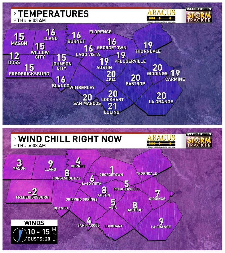
Brutal, brutal, brutal cold this morning. Put on every layer you've got.
Single-digit wind chill temperatures already as of 5:30 AM, and we'll keep dropping through about 9 AM. Odds are, we won't get above freezing this afternoon
Single-digit wind chill temperatures already as of 5:30 AM, and we'll keep dropping through about 9 AM. Odds are, we won't get above freezing this afternoon

February 19, 2025 at 11:23 AM
Brutal, brutal, brutal cold this morning. Put on every layer you've got.
Single-digit wind chill temperatures already as of 5:30 AM, and we'll keep dropping through about 9 AM. Odds are, we won't get above freezing this afternoon
Single-digit wind chill temperatures already as of 5:30 AM, and we'll keep dropping through about 9 AM. Odds are, we won't get above freezing this afternoon
First look at the first of two dangerously cold nights in Central Texas.
WEDNESDAY MORNING
🔹Air temps: 15-25°
🔹Wind speed: 15-25 MPH
🔹Wind chill: 0-15°
B r u t a l. Genuine concern for hypothermia if you're outside for too long without the right gear
WEDNESDAY MORNING
🔹Air temps: 15-25°
🔹Wind speed: 15-25 MPH
🔹Wind chill: 0-15°
B r u t a l. Genuine concern for hypothermia if you're outside for too long without the right gear

February 18, 2025 at 12:05 PM
First look at the first of two dangerously cold nights in Central Texas.
WEDNESDAY MORNING
🔹Air temps: 15-25°
🔹Wind speed: 15-25 MPH
🔹Wind chill: 0-15°
B r u t a l. Genuine concern for hypothermia if you're outside for too long without the right gear
WEDNESDAY MORNING
🔹Air temps: 15-25°
🔹Wind speed: 15-25 MPH
🔹Wind chill: 0-15°
B r u t a l. Genuine concern for hypothermia if you're outside for too long without the right gear
Everything you had to do back in January.
Pipes prone to freezing need to be covered. Drip a few interior faucets. Keep pets inside. Cover up outdoor plants. Protect yourself with lots-o-layers, and check on friends/neighbors/family that may need some help
Pipes prone to freezing need to be covered. Drip a few interior faucets. Keep pets inside. Cover up outdoor plants. Protect yourself with lots-o-layers, and check on friends/neighbors/family that may need some help

February 18, 2025 at 12:22 AM
Everything you had to do back in January.
Pipes prone to freezing need to be covered. Drip a few interior faucets. Keep pets inside. Cover up outdoor plants. Protect yourself with lots-o-layers, and check on friends/neighbors/family that may need some help
Pipes prone to freezing need to be covered. Drip a few interior faucets. Keep pets inside. Cover up outdoor plants. Protect yourself with lots-o-layers, and check on friends/neighbors/family that may need some help
Buckle up, scallywags.
Dangerous cold whips through Texas TUESDAY NIGHT. Single-digit wind chill temperatures expected Wednesday and Thursday mornings.
Pets, pipes, people, plants, and pants. Please wear pants and make good choices
Dangerous cold whips through Texas TUESDAY NIGHT. Single-digit wind chill temperatures expected Wednesday and Thursday mornings.
Pets, pipes, people, plants, and pants. Please wear pants and make good choices

February 17, 2025 at 12:36 PM
Buckle up, scallywags.
Dangerous cold whips through Texas TUESDAY NIGHT. Single-digit wind chill temperatures expected Wednesday and Thursday mornings.
Pets, pipes, people, plants, and pants. Please wear pants and make good choices
Dangerous cold whips through Texas TUESDAY NIGHT. Single-digit wind chill temperatures expected Wednesday and Thursday mornings.
Pets, pipes, people, plants, and pants. Please wear pants and make good choices