


Reposted

What made the above-average 2025 #HurricaneSeason unusual?
- Least amount of Accumulated Cyclone Energy since 2022
- No U.S. hurricane landfalls for the first time since 2015
- Latest first named storm formation since 2014
- Three Category 5 hurricanes, second only to the 2005 season
- Least amount of Accumulated Cyclone Energy since 2022
- No U.S. hurricane landfalls for the first time since 2015
- Latest first named storm formation since 2014
- Three Category 5 hurricanes, second only to the 2005 season

Summary of the Unusual 2025 Hurricane Season
Updates and summaries on tropical Atlantic activity... including easterly waves, tropical storms, subtropical storms, and hurricanes.
bmcnoldy.blogspot.com
November 17, 2025 at 1:06 PM
What made the above-average 2025 #HurricaneSeason unusual?
- Least amount of Accumulated Cyclone Energy since 2022
- No U.S. hurricane landfalls for the first time since 2015
- Latest first named storm formation since 2014
- Three Category 5 hurricanes, second only to the 2005 season
- Least amount of Accumulated Cyclone Energy since 2022
- No U.S. hurricane landfalls for the first time since 2015
- Latest first named storm formation since 2014
- Three Category 5 hurricanes, second only to the 2005 season
Reposted

Following Hurricane Melissa's devastation, Jamaica’s decade-long effort to build financial resilience will be tested. Its $150 million catastrophe bond, triggered by a storm’s low pressure and path, will provide quick relief. Jamaica’s model may serve as a guide for other climate-vulnerable nations.

Jamaica invested heavily in climate disaster insurance. It looks about to pay off | CBC News
Jamaica’s decade-long effort to build layers of financial protection in case of natural disasters might help the country access millions of dollars in the immediate aftermath of Hurricane Melissa — an...
www.cbc.ca
October 30, 2025 at 4:20 PM
Following Hurricane Melissa's devastation, Jamaica’s decade-long effort to build financial resilience will be tested. Its $150 million catastrophe bond, triggered by a storm’s low pressure and path, will provide quick relief. Jamaica’s model may serve as a guide for other climate-vulnerable nations.
Reposted

Melissa proved to be not only one of the strongest hurricanes on record, but one of the most durable and resilient Category 5s we've ever seen. In today's newsletter, I discuss why it stayed so strong for so long as where Melissa's headed next. ⬇️

Melissa Strikes Eastern Cuba after Ravaging Jamaica
Melissa is the strongest hurricane to hit eastern Cuba in 9 years
michaelrlowry.substack.com
October 29, 2025 at 4:35 PM
Melissa proved to be not only one of the strongest hurricanes on record, but one of the most durable and resilient Category 5s we've ever seen. In today's newsletter, I discuss why it stayed so strong for so long as where Melissa's headed next. ⬇️
Reposted

After passing over Jamaica yesterday, Hurricane Melissa made another landfall in southeastern Cuba last night.
Melissa has now moved back over water north of Cuba, and will traverse over the Bahamas later today.
Melissa has now moved back over water north of Cuba, and will traverse over the Bahamas later today.
October 29, 2025 at 5:15 PM
After passing over Jamaica yesterday, Hurricane Melissa made another landfall in southeastern Cuba last night.
Melissa has now moved back over water north of Cuba, and will traverse over the Bahamas later today.
Melissa has now moved back over water north of Cuba, and will traverse over the Bahamas later today.
Reposted

Atlantic Hurricane Melissa Intermediate Advisory Number 32a issued at Wed, 29 Oct 2025 11:49:28 +0000
...MELISSA CONTINUES TO MOVE OVER EASTERN CUBA AND WILL SOON EMERGE INTO THE SOUTHWESTERN ATLANTIC, BRINGING DAMAGING WINDS, FLOODING RAINS, AND DANGEROUS STORM SU...
Additional Details Here.
...MELISSA CONTINUES TO MOVE OVER EASTERN CUBA AND WILL SOON EMERGE INTO THE SOUTHWESTERN ATLANTIC, BRINGING DAMAGING WINDS, FLOODING RAINS, AND DANGEROUS STORM SU...
Additional Details Here.


October 29, 2025 at 11:50 AM
Atlantic Hurricane Melissa Intermediate Advisory Number 32a issued at Wed, 29 Oct 2025 11:49:28 +0000
...MELISSA CONTINUES TO MOVE OVER EASTERN CUBA AND WILL SOON EMERGE INTO THE SOUTHWESTERN ATLANTIC, BRINGING DAMAGING WINDS, FLOODING RAINS, AND DANGEROUS STORM SU...
Additional Details Here.
...MELISSA CONTINUES TO MOVE OVER EASTERN CUBA AND WILL SOON EMERGE INTO THE SOUTHWESTERN ATLANTIC, BRINGING DAMAGING WINDS, FLOODING RAINS, AND DANGEROUS STORM SU...
Additional Details Here.
Reposted
Slow-moving #Melissa was quite effective at extracting energy from the warm water below it. This 10-day loop of ocean heat content tells the story, and more decreases will show up closer to Jamaica and Cuba in the coming days.
[1/2]
[1/2]
October 29, 2025 at 1:17 PM
Slow-moving #Melissa was quite effective at extracting energy from the warm water below it. This 10-day loop of ocean heat content tells the story, and more decreases will show up closer to Jamaica and Cuba in the coming days.
[1/2]
[1/2]
Reposted
Atlantic Hurricane Melissa Advisory Number 32 issued at Wed, 29 Oct 2025 08:51:54 +0000
...MELISSA BRINGING DAMAGING WINDS, FLOODING RAINS, AND DANGEROUS STORM SURGE AS IT MOVES OVER EASTERN CUBA...
Additional Details Here.
...MELISSA BRINGING DAMAGING WINDS, FLOODING RAINS, AND DANGEROUS STORM SURGE AS IT MOVES OVER EASTERN CUBA...
Additional Details Here.


October 29, 2025 at 9:00 AM
Atlantic Hurricane Melissa Advisory Number 32 issued at Wed, 29 Oct 2025 08:51:54 +0000
...MELISSA BRINGING DAMAGING WINDS, FLOODING RAINS, AND DANGEROUS STORM SURGE AS IT MOVES OVER EASTERN CUBA...
Additional Details Here.
...MELISSA BRINGING DAMAGING WINDS, FLOODING RAINS, AND DANGEROUS STORM SURGE AS IT MOVES OVER EASTERN CUBA...
Additional Details Here.
Reposted

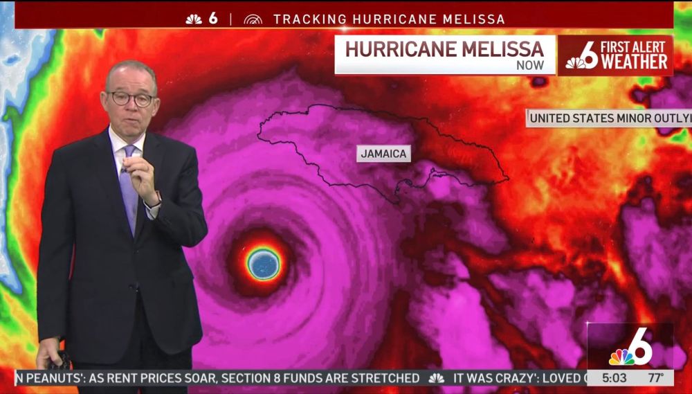
At NBC 6 since 4 am and until Melissa’s landfall this morning. Impacts in Jamaica are increasing as their strongest hurricane on record approaches. Winds 175 mph (280 km/hr) with gust factor of 1.5x➕ speeded up by hills & mountains. 13 ft (4 m) storm surge. 30-40 inches (1000 mm) storm total precip
October 28, 2025 at 11:43 AM
At NBC 6 since 4 am and until Melissa’s landfall this morning. Impacts in Jamaica are increasing as their strongest hurricane on record approaches. Winds 175 mph (280 km/hr) with gust factor of 1.5x➕ speeded up by hills & mountains. 13 ft (4 m) storm surge. 30-40 inches (1000 mm) storm total precip
Reposted

If you read my stuff often, you'll probably detect a shift in tone tonight. It felt weird writing it. Truly hoping for the best but my goodness this is bad.

A sinking feeling as we look at Melissa this evening. Here’s an evening update and reaction to what it has done today. Link below or at theeyewall.com

Hurricane Melissa enters the elite club of the 20 most powerful Atlantic hurricanes in the satellite era
And it may not be entirely done strengthening yet
open.substack.com
October 28, 2025 at 12:22 AM
If you read my stuff often, you'll probably detect a shift in tone tonight. It felt weird writing it. Truly hoping for the best but my goodness this is bad.
Reposted

In my 30 years being a professional meteorologist, I can't say I have ever seen a #Hurricane with better/ more textbook structure than #Melissa in the Atlantic.
It's been a Cat 5 all day long with no signs of getting any weaker. That's a rare run! Here's more...
It's been a Cat 5 all day long with no signs of getting any weaker. That's a rare run! Here's more...
October 28, 2025 at 12:50 AM
In my 30 years being a professional meteorologist, I can't say I have ever seen a #Hurricane with better/ more textbook structure than #Melissa in the Atlantic.
It's been a Cat 5 all day long with no signs of getting any weaker. That's a rare run! Here's more...
It's been a Cat 5 all day long with no signs of getting any weaker. That's a rare run! Here's more...
Reposted

Heartbreaking visible image of a potentially generational storm, and a likely reflection of broader trends—greater ocean warmth and depth of warmth, faster intensification rates, slower forward speeds, and greater rainfall rates.

October 26, 2025 at 1:03 PM
Heartbreaking visible image of a potentially generational storm, and a likely reflection of broader trends—greater ocean warmth and depth of warmth, faster intensification rates, slower forward speeds, and greater rainfall rates.
Reposted
Sunrise on Hurricane Melissa.
Melissa is now a Category 4 storm with sustained winds of 140 mph.
Melissa is now a Category 4 storm with sustained winds of 140 mph.
October 26, 2025 at 2:59 PM
Sunrise on Hurricane Melissa.
Melissa is now a Category 4 storm with sustained winds of 140 mph.
Melissa is now a Category 4 storm with sustained winds of 140 mph.
Reposted
Atlantic Tropical Storm Melissa Advisory Number 12 issued at Fri, 24 Oct 2025 08:41:25 +0000
...MELISSA NEARLY STATIONARY... ...LIFE-THREATENING AND CATASTROPHIC FLASH FLOODING AND LANDSLIDES EXPECTED IN PORTIONS OF SOUTHERN HISPANIOLA AND JAMAICA THROUGH THE WEEKEND...
Additional Details Here.
...MELISSA NEARLY STATIONARY... ...LIFE-THREATENING AND CATASTROPHIC FLASH FLOODING AND LANDSLIDES EXPECTED IN PORTIONS OF SOUTHERN HISPANIOLA AND JAMAICA THROUGH THE WEEKEND...
Additional Details Here.


October 24, 2025 at 8:50 AM
Atlantic Tropical Storm Melissa Advisory Number 12 issued at Fri, 24 Oct 2025 08:41:25 +0000
...MELISSA NEARLY STATIONARY... ...LIFE-THREATENING AND CATASTROPHIC FLASH FLOODING AND LANDSLIDES EXPECTED IN PORTIONS OF SOUTHERN HISPANIOLA AND JAMAICA THROUGH THE WEEKEND...
Additional Details Here.
...MELISSA NEARLY STATIONARY... ...LIFE-THREATENING AND CATASTROPHIC FLASH FLOODING AND LANDSLIDES EXPECTED IN PORTIONS OF SOUTHERN HISPANIOLA AND JAMAICA THROUGH THE WEEKEND...
Additional Details Here.
Reposted
Another "pit in stomach" forecast. Looks very bad for Haiti and Jamaica and perhaps Cuba.
Here is our evening update on Melissa, which looks increasingly likely to be a catastrophic storm for parts of the Caribbean. We explain how it should start to get its act together, where it will go, and how much rain we expect to see (a lot).

Melissa continues to look like a slow-moving disaster for parts of the Caribbean
A slow moving, moisture-loaded major hurricane looks like from Sunday through Tuesday near Jamaica
open.substack.com
October 24, 2025 at 1:07 AM
Another "pit in stomach" forecast. Looks very bad for Haiti and Jamaica and perhaps Cuba.
Reposted
Atlantic Tropical Storm Melissa Intermediate Advisory Number 8a issued at Thu, 23 Oct 2025 11:57:00 +0000
...HURRICANE WATCH NOW IN EFFECT FOR JAMAICA... ...HEAVY RAINS AND LIFE-THREATENING FLOODING EXPECTED FOR PORTIONS OF HISPANIOLA AND JAMAICA THROUGH THE WEEKEND...
Additional Details Here.
...HURRICANE WATCH NOW IN EFFECT FOR JAMAICA... ...HEAVY RAINS AND LIFE-THREATENING FLOODING EXPECTED FOR PORTIONS OF HISPANIOLA AND JAMAICA THROUGH THE WEEKEND...
Additional Details Here.


October 23, 2025 at 12:00 PM
Atlantic Tropical Storm Melissa Intermediate Advisory Number 8a issued at Thu, 23 Oct 2025 11:57:00 +0000
...HURRICANE WATCH NOW IN EFFECT FOR JAMAICA... ...HEAVY RAINS AND LIFE-THREATENING FLOODING EXPECTED FOR PORTIONS OF HISPANIOLA AND JAMAICA THROUGH THE WEEKEND...
Additional Details Here.
...HURRICANE WATCH NOW IN EFFECT FOR JAMAICA... ...HEAVY RAINS AND LIFE-THREATENING FLOODING EXPECTED FOR PORTIONS OF HISPANIOLA AND JAMAICA THROUGH THE WEEKEND...
Additional Details Here.
Reposted
How is the Google DeepMind model doing so far this Atlantic hurricane season?
My *preliminary* homogeneous verification shows that the DeepMind ensemble mean "GDMN" is dominating in both track and intensity, beating the revered "HCCA" consensus and the NHC ("OFCL") at all/most lead times.
[1/2]
My *preliminary* homogeneous verification shows that the DeepMind ensemble mean "GDMN" is dominating in both track and intensity, beating the revered "HCCA" consensus and the NHC ("OFCL") at all/most lead times.
[1/2]


October 22, 2025 at 5:50 PM
How is the Google DeepMind model doing so far this Atlantic hurricane season?
My *preliminary* homogeneous verification shows that the DeepMind ensemble mean "GDMN" is dominating in both track and intensity, beating the revered "HCCA" consensus and the NHC ("OFCL") at all/most lead times.
[1/2]
My *preliminary* homogeneous verification shows that the DeepMind ensemble mean "GDMN" is dominating in both track and intensity, beating the revered "HCCA" consensus and the NHC ("OFCL") at all/most lead times.
[1/2]
Reposted

The trend to the west with #melissa has continued overnight. The AM runs will be coming in soon. The longer this westward trend continues the greater the risk there will be for a major hurricane down the road. Current #NHC forecast is for a CAT2. Stay with #weshwx for updates.

October 22, 2025 at 2:08 PM
Reposted
If the forecast scenario of an "M" storm in October cruising into the Caribbean, stalling, and turning north as a major hurricane seems familiar to you, it should: this outcome would be remarkably similar to what we saw with Matthew in 2016.
bmcnoldy.blogspot.com/2025/10/meli...
#Melissa
bmcnoldy.blogspot.com/2025/10/meli...
#Melissa

October 21, 2025 at 7:44 PM
If the forecast scenario of an "M" storm in October cruising into the Caribbean, stalling, and turning north as a major hurricane seems familiar to you, it should: this outcome would be remarkably similar to what we saw with Matthew in 2016.
bmcnoldy.blogspot.com/2025/10/meli...
#Melissa
bmcnoldy.blogspot.com/2025/10/meli...
#Melissa
Reposted
The "cone of uncertainty" is identical in size for all Atlantic storms this entire season... these examples are from Jerry and #Melissa.
Confused? Check out bmcnoldy.blogspot.com/2025/03/2025...
Confused? Check out bmcnoldy.blogspot.com/2025/03/2025...


October 21, 2025 at 8:36 PM
The "cone of uncertainty" is identical in size for all Atlantic storms this entire season... these examples are from Jerry and #Melissa.
Confused? Check out bmcnoldy.blogspot.com/2025/03/2025...
Confused? Check out bmcnoldy.blogspot.com/2025/03/2025...
Reposted
Folks, this is why slow moving storms near Haiti and the DR can be so very dangerous. The mountains force air to rise rapidly and squeeze out copious moisture. The runoff often inundates villages. If this track verifies, it’s extremely dangerous. #Melissa
October 21, 2025 at 10:32 PM
Folks, this is why slow moving storms near Haiti and the DR can be so very dangerous. The mountains force air to rise rapidly and squeeze out copious moisture. The runoff often inundates villages. If this track verifies, it’s extremely dangerous. #Melissa
Reposted
Thanks to @burgwx.bsky.social this image contains all tracks from last night’s model ensembles (both physical and AI) for newly formed #Melissa. Any track along or to the right of the mean (black line) spells days of excessive rain and life threatening floods in Haiti and parts of the Dominican Rep.

October 21, 2025 at 2:42 PM
Thanks to @burgwx.bsky.social this image contains all tracks from last night’s model ensembles (both physical and AI) for newly formed #Melissa. Any track along or to the right of the mean (black line) spells days of excessive rain and life threatening floods in Haiti and parts of the Dominican Rep.
Reposted
The ocean heat content is exceptionally high for this time of year across much of the Caribbean, so even a stalled storm will not be able to upwell cooler water from below. The Caribbean is famously an endless fuel source for hurricanes, and these huge anomalies only boost that further.
#Melissa
#Melissa

Melissa forms in Caribbean, forecast to intensify and stall over exceptionally warm water
Updates and summaries on tropical Atlantic activity... including easterly waves, tropical storms, subtropical storms, and hurricanes.
bmcnoldy.blogspot.com
October 21, 2025 at 5:25 PM
The ocean heat content is exceptionally high for this time of year across much of the Caribbean, so even a stalled storm will not be able to upwell cooler water from below. The Caribbean is famously an endless fuel source for hurricanes, and these huge anomalies only boost that further.
#Melissa
#Melissa
Reposted

I usually don't post about a new feature before it's complete, but in the interest of timeliness with an uncertain path for invest 98L, I've been working on implementing a 360-member grand ensemble consisting of 9 ensemble suites (NWP + AI). Here is its latest projection for 98L:

October 21, 2025 at 12:42 AM
I usually don't post about a new feature before it's complete, but in the interest of timeliness with an uncertain path for invest 98L, I've been working on implementing a 360-member grand ensemble consisting of 9 ensemble suites (NWP + AI). Here is its latest projection for 98L:
Reposted

The main event for the 2025 Atlantic hurricane season, as far as life-threatening impacts go, could well be unfolding in the Caribbean this week, as @bhensonweather.bsky.social and I explain: yaleclimateconnections.org/2025/10/trop...

Tropical disturbance poses torrential rainfall threat for the central Caribbean » Yale Climate Connections
No matter whether Invest 98L becomes a tropical storm later this week, it could lead to serious flooding.
yaleclimateconnections.org
October 20, 2025 at 4:41 PM
The main event for the 2025 Atlantic hurricane season, as far as life-threatening impacts go, could well be unfolding in the Caribbean this week, as @bhensonweather.bsky.social and I explain: yaleclimateconnections.org/2025/10/trop...