


Alan Snyder
@alansnyderwx.bsky.social
Just a guy that loves weather
Reposted by Alan Snyder

#Hurricane #Kiko is currently intensifying in the open Eastern Pacific. The current BT intensity is set at 90 kt and Kiko is expected to peak as a Category 3 in the coming days. Hawaii may want to watch out for downstream impacts in the coming week or two.


September 3, 2025 at 1:53 AM
#Hurricane #Kiko is currently intensifying in the open Eastern Pacific. The current BT intensity is set at 90 kt and Kiko is expected to peak as a Category 3 in the coming days. Hawaii may want to watch out for downstream impacts in the coming week or two.
Reposted by Alan Snyder
#erin appears to be strengthening as MW depicts half of a low level core. In addition, convection has blossomed post DMIN. SSTs are still a bit cool so I doubt Erin will strengthen a ton over the next day or so but Erin has potential to become a major #hurricane in a few days.


August 12, 2025 at 12:15 AM
#erin appears to be strengthening as MW depicts half of a low level core. In addition, convection has blossomed post DMIN. SSTs are still a bit cool so I doubt Erin will strengthen a ton over the next day or so but Erin has potential to become a major #hurricane in a few days.
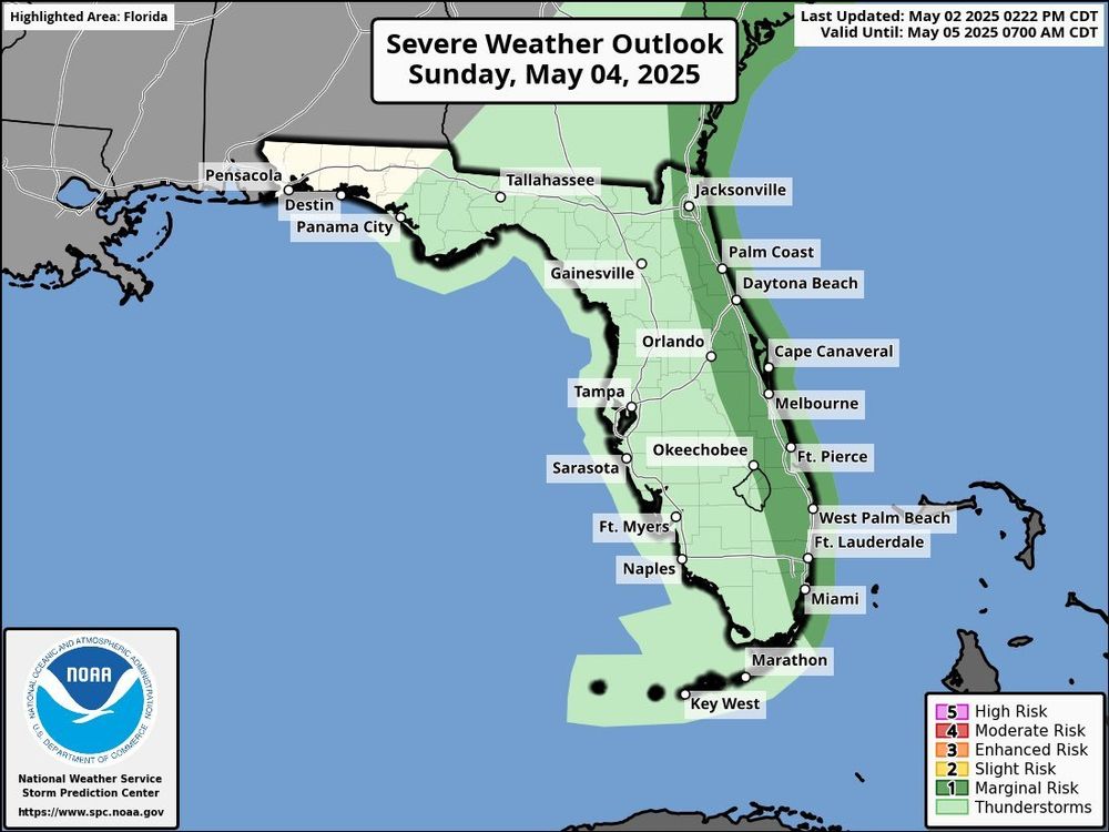
There is a Day 3 marginal risk for severe weather on Sunday for all of eastern Florida. A Front will come to provide come beneficial rains for the state. but along the way it is possible that a few strong storms can pop up. I Will have more on this tomorrow.
May 2, 2025 at 10:12 PM
There is a Day 3 marginal risk for severe weather on Sunday for all of eastern Florida. A Front will come to provide come beneficial rains for the state. but along the way it is possible that a few strong storms can pop up. I Will have more on this tomorrow.
Reposted by Alan Snyder

Fun subtropical depression attempt northeast of the Leeward Islands. No fronts are analyzed into the center.


May 2, 2025 at 8:32 PM
Fun subtropical depression attempt northeast of the Leeward Islands. No fronts are analyzed into the center.
I Will probably make a comeback to this platform soon. Stay on the lookout :)
April 28, 2025 at 8:46 PM
I Will probably make a comeback to this platform soon. Stay on the lookout :)
Tropical Cyclone 04S has formed in the Southwest Indian ocean this afternoon with winds of 45 mph and a pressure of 1000 MB. it has become more organized over the past few hours and has become more aligned with it's MLC and LLC. some gradual strengthening is possible over the coming days.


December 9, 2024 at 10:08 PM
Tropical Cyclone 04S has formed in the Southwest Indian ocean this afternoon with winds of 45 mph and a pressure of 1000 MB. it has become more organized over the past few hours and has become more aligned with it's MLC and LLC. some gradual strengthening is possible over the coming days.
Robyn has become a Category 1 Cyclone with winds of 75 MPH and a pressure down to 985 MPH. This is likely peak as Vertical Wind Shear starts to pick up tonight. #Cyclone #TropicalWeather #Weather

November 28, 2024 at 7:09 PM
Robyn has become a Category 1 Cyclone with winds of 75 MPH and a pressure down to 985 MPH. This is likely peak as Vertical Wind Shear starts to pick up tonight. #Cyclone #TropicalWeather #Weather


03S THREE 241127 1200 12.7S 91.2E SHEM 35 995
Looks like we have 03S according to JTWC. it has winds of 40 MPH and a pressure of 995 MB. Some slight additional Strength is possible, before conditions start to become less conducive.
Looks like we have 03S according to JTWC. it has winds of 40 MPH and a pressure of 995 MB. Some slight additional Strength is possible, before conditions start to become less conducive.
November 27, 2024 at 2:00 PM
03S THREE 241127 1200 12.7S 91.2E SHEM 35 995
Looks like we have 03S according to JTWC. it has winds of 40 MPH and a pressure of 995 MB. Some slight additional Strength is possible, before conditions start to become less conducive.
Looks like we have 03S according to JTWC. it has winds of 40 MPH and a pressure of 995 MB. Some slight additional Strength is possible, before conditions start to become less conducive.
There is an Tropical Cyclone Formation Alert out for Invest 96S this afternoon. ASCAT showed that it was pretty much a Tropical Storm at this point with about 35 knot winds. Since it's in the BoM AoR it won't get named until it has 75% of all quads with TS force winds, or unless it passes 90E

November 26, 2024 at 9:18 PM
There is an Tropical Cyclone Formation Alert out for Invest 96S this afternoon. ASCAT showed that it was pretty much a Tropical Storm at this point with about 35 knot winds. Since it's in the BoM AoR it won't get named until it has 75% of all quads with TS force winds, or unless it passes 90E
The signal for 96S/01U has been slowly increasing again over the last couple of days. I would expect anywhere from a broad slop, to a Tropical Storm, to a Category 1 Cyclone. At least for the time being. We will see if we get more than that when we start seeing it consolidate real time. #tropics

November 24, 2024 at 12:23 PM
The signal for 96S/01U has been slowly increasing again over the last couple of days. I would expect anywhere from a broad slop, to a Tropical Storm, to a Category 1 Cyclone. At least for the time being. We will see if we get more than that when we start seeing it consolidate real time. #tropics
It is possible in the coming week that we could see Twin Tropical Cyclones in the NIO and the SWIO/AUS Regions. Where 01U ( 96S ) Has a medium chance of development. We will have to see how things plan out. But the latest model runs have been back and forth.


November 22, 2024 at 2:59 AM
It is possible in the coming week that we could see Twin Tropical Cyclones in the NIO and the SWIO/AUS Regions. Where 01U ( 96S ) Has a medium chance of development. We will have to see how things plan out. But the latest model runs have been back and forth.
I finally find myself on blue sky. just like on twitter i will have Tropical Cyclone updates from official sources, as well as my own take on things. hope to enjoy the stay on the blue sky
November 22, 2024 at 1:19 AM
I finally find myself on blue sky. just like on twitter i will have Tropical Cyclone updates from official sources, as well as my own take on things. hope to enjoy the stay on the blue sky