


Aaron Zuspan
@aazuspan.dev
🛰️🌲🔥 Researcher at Oregon State University / Earth observation and fire / open source geospatial / Python / Earth Engine
aazuspan.dev
aazuspan.dev
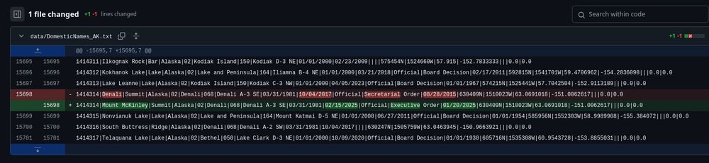
I made a Github repository a few days ago to automatically track changes to the GNIS database of place names in the US.
Apparently it works.
#Denali
Apparently it works.
#Denali
February 21, 2025 at 12:28 AM
I made a Github repository a few days ago to automatically track changes to the GNIS database of place names in the US.
Apparently it works.
#Denali
Apparently it works.
#Denali
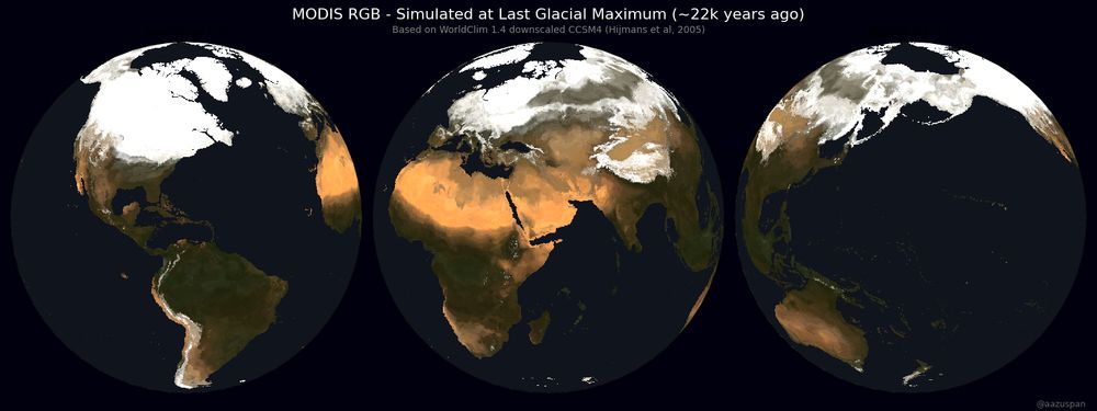
Am I too late for #30DayMapChallenge Day 14 - A World Map?
I trained a model to predict MODIS RGB imagery from modern climate and applied it to modeled paleoclimate data to simulate a 22,000 year old satellite image of Earth
I trained a model to predict MODIS RGB imagery from modern climate and applied it to modeled paleoclimate data to simulate a 22,000 year old satellite image of Earth
December 8, 2024 at 8:15 PM
Am I too late for #30DayMapChallenge Day 14 - A World Map?
I trained a model to predict MODIS RGB imagery from modern climate and applied it to modeled paleoclimate data to simulate a 22,000 year old satellite image of Earth
I trained a model to predict MODIS RGB imagery from modern climate and applied it to modeled paleoclimate data to simulate a 22,000 year old satellite image of Earth
Reposted by Aaron Zuspan
This was my tenth(!) year building 25 days of puzzles for #AdventOfCode. You can solve them all for free! Most people write code to solve them, but you can solve them however you like. I hope they help people become better programmers. 🌟
The first puzzle comes out in two hours: adventofcode.com
The first puzzle comes out in two hours: adventofcode.com
Advent of Code 2024
adventofcode.com
December 1, 2024 at 2:57 AM
This was my tenth(!) year building 25 days of puzzles for #AdventOfCode. You can solve them all for free! Most people write code to solve them, but you can solve them however you like. I hope they help people become better programmers. 🌟
The first puzzle comes out in two hours: adventofcode.com
The first puzzle comes out in two hours: adventofcode.com
Reposted by Aaron Zuspan

Please help us test the first release candidate for scikit-learn 1.6: pip install scikit-learn==1.6.0rc1
Changelog: scikit-learn.org/1.6/whats_ne...
In particular, if you maintain a project with a dependency on
scikit-learn, please let us know about any regression.
Changelog: scikit-learn.org/1.6/whats_ne...
In particular, if you maintain a project with a dependency on
scikit-learn, please let us know about any regression.

Version 1.6
Legend for changelogs something big that you couldn’t do before., something that you couldn’t do before., an existing feature now may not require as much computation or memory., a miscellaneous min...
scikit-learn.org
November 22, 2024 at 2:49 PM
Please help us test the first release candidate for scikit-learn 1.6: pip install scikit-learn==1.6.0rc1
Changelog: scikit-learn.org/1.6/whats_ne...
In particular, if you maintain a project with a dependency on
scikit-learn, please let us know about any regression.
Changelog: scikit-learn.org/1.6/whats_ne...
In particular, if you maintain a project with a dependency on
scikit-learn, please let us know about any regression.
Reposted by Aaron Zuspan

Foursquare just open sourced their 100 million place point of interest dataset! Some notes on poking around with it using DuckDB (it's Parquet files on S3) simonwillison.net/2024/Nov/20/...
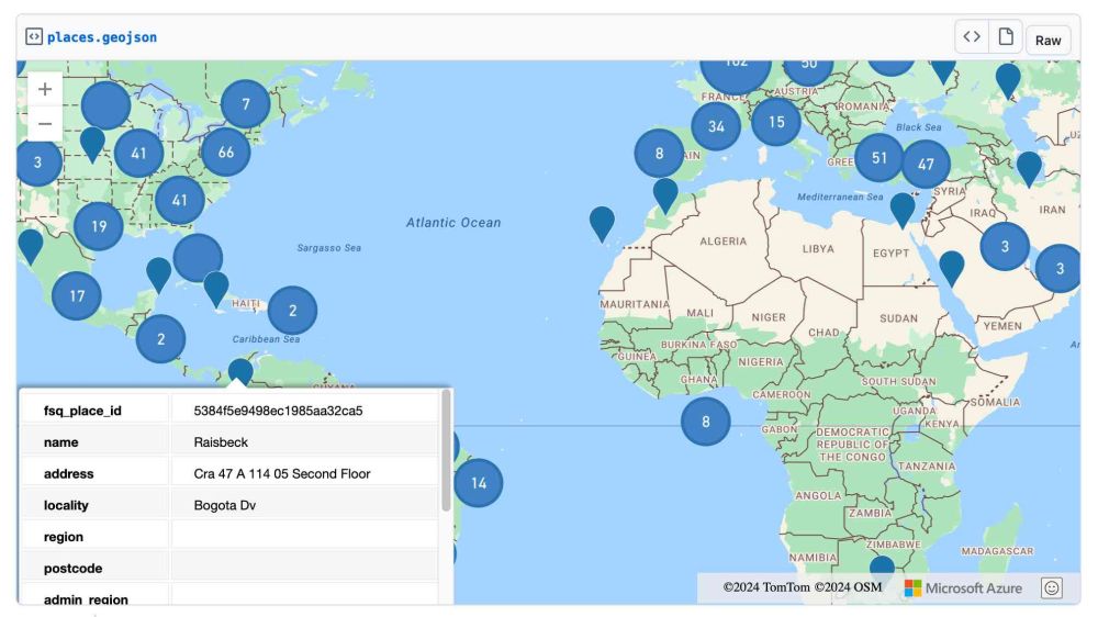
Foursquare Open Source Places: A new foundational dataset for the geospatial community
I did not expect this! > [...] we are announcing today the general availability of a foundational open data set, Foursquare Open Source Places ("FSQ OS Places"). This base layer …
simonwillison.net
November 20, 2024 at 6:08 AM
Foursquare just open sourced their 100 million place point of interest dataset! Some notes on poking around with it using DuckDB (it's Parquet files on S3) simonwillison.net/2024/Nov/20/...
Reposted by Aaron Zuspan

Many fail to understand how the location of receiving stations impacted early data collection of polar orbiting satellites in the early days. That's the circular pattern in the early data.
In former life I re-processed 1978-1991 vis/ir data back when Dinosaurs Walked (data on tape reels)
In former life I re-processed 1978-1991 vis/ir data back when Dinosaurs Walked (data on tape reels)
#30DayMapChallenge, Day 12: Time and Space
51 years and 11 million #Landsat scenes, showing global cloud-free (<20%) coverage by path and row since Landsat 1 🛰️
51 years and 11 million #Landsat scenes, showing global cloud-free (<20%) coverage by path and row since Landsat 1 🛰️
November 13, 2024 at 9:53 AM
Many fail to understand how the location of receiving stations impacted early data collection of polar orbiting satellites in the early days. That's the circular pattern in the early data.
In former life I re-processed 1978-1991 vis/ir data back when Dinosaurs Walked (data on tape reels)
In former life I re-processed 1978-1991 vis/ir data back when Dinosaurs Walked (data on tape reels)
Reposted by Aaron Zuspan

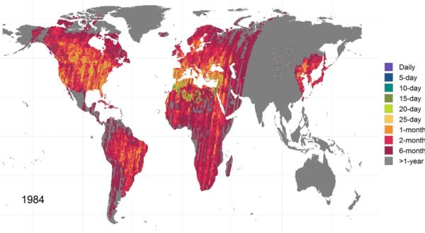
We all think we know how much #Landsat and #Sentinel-2 data is in the archives🛰️
🌍 Global edition
🚨 See our new paper and dataset to check 1982-2023 data availability for your study site:
tinyurl.com/yc82epfx
#GEE data viewer: tinyurl.com/322e63p2
🌍 Global edition
🚨 See our new paper and dataset to check 1982-2023 data availability for your study site:
tinyurl.com/yc82epfx
#GEE data viewer: tinyurl.com/322e63p2
October 22, 2024 at 8:43 AM
We all think we know how much #Landsat and #Sentinel-2 data is in the archives🛰️
🌍 Global edition
🚨 See our new paper and dataset to check 1982-2023 data availability for your study site:
tinyurl.com/yc82epfx
#GEE data viewer: tinyurl.com/322e63p2
🌍 Global edition
🚨 See our new paper and dataset to check 1982-2023 data availability for your study site:
tinyurl.com/yc82epfx
#GEE data viewer: tinyurl.com/322e63p2
#30DayMapChallenge, Day 12: Time and Space
51 years and 11 million #Landsat scenes, showing global cloud-free (<20%) coverage by path and row since Landsat 1 🛰️
51 years and 11 million #Landsat scenes, showing global cloud-free (<20%) coverage by path and row since Landsat 1 🛰️
November 13, 2024 at 1:28 AM
#30DayMapChallenge, Day 12: Time and Space
51 years and 11 million #Landsat scenes, showing global cloud-free (<20%) coverage by path and row since Landsat 1 🛰️
51 years and 11 million #Landsat scenes, showing global cloud-free (<20%) coverage by path and row since Landsat 1 🛰️
Reposted by Aaron Zuspan

#30DayMapChallenge Day 11: Arctic
One year of MODIS daily mosaic images
Did you know optical satellites like MODIS usually don't capture images over the poles in winter due to lack of sunlight? The "no data" hole grows as we near the winter solstice - and starts closing once daylight returns
One year of MODIS daily mosaic images
Did you know optical satellites like MODIS usually don't capture images over the poles in winter due to lack of sunlight? The "no data" hole grows as we near the winter solstice - and starts closing once daylight returns
November 11, 2024 at 10:18 AM
#30DayMapChallenge Day 11: Arctic
One year of MODIS daily mosaic images
Did you know optical satellites like MODIS usually don't capture images over the poles in winter due to lack of sunlight? The "no data" hole grows as we near the winter solstice - and starts closing once daylight returns
One year of MODIS daily mosaic images
Did you know optical satellites like MODIS usually don't capture images over the poles in winter due to lack of sunlight? The "no data" hole grows as we near the winter solstice - and starts closing once daylight returns
Visualizing how daylight hours change through the year depending on your latitude, for a blog post where I tried to figure out how far you'd need to travel to keep the same day length year-round (spoiler: not very far at first, then REALLY far at each equinox)
www.aazuspan.dev/blog/chasing...
www.aazuspan.dev/blog/chasing...
November 10, 2024 at 6:56 AM
Visualizing how daylight hours change through the year depending on your latitude, for a blog post where I tried to figure out how far you'd need to travel to keep the same day length year-round (spoiler: not very far at first, then REALLY far at each equinox)
www.aazuspan.dev/blog/chasing...
www.aazuspan.dev/blog/chasing...