


Shel Winkley
@shelwinkleywx.bsky.social
@climatecentral.org | Former KBTX Chief Meteorologist | AMS CBM #780 | TAMU Class of 2007 | 🔴 🌎 Climate Change is Real.
Weather can be wonky — natural variability happens. But human-made carbon pollution is turning extreme weather from expected to unnatural.
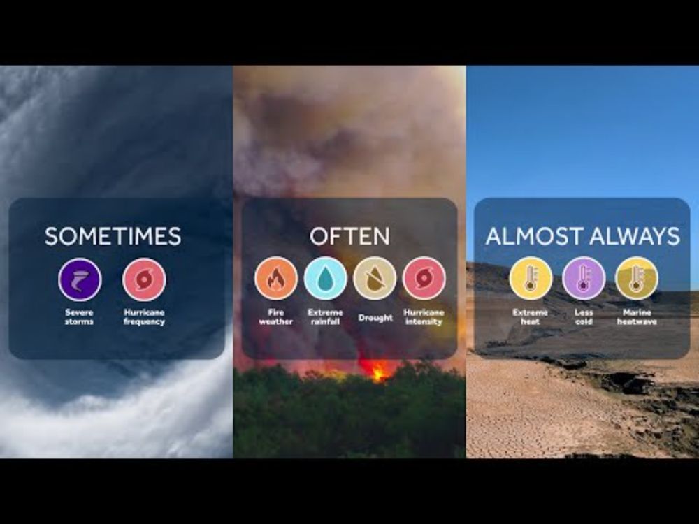
🍿 A 2-minute CliffNotes on how attribution science connects the fingerprint of climate change to show how much more likely or intense events are 👇
🍿 A 2-minute CliffNotes on how attribution science connects the fingerprint of climate change to show how much more likely or intense events are 👇
Ever wonder how scientists can say climate change made an extreme weather event more likely or more intense?
That’s attribution science at work.
It compares today’s world to one without the extra heat we’ve added through heat-trapping carbon pollution.
📺Learn more⤵️
youtu.be/A2vUBBkEOjA
That’s attribution science at work.
It compares today’s world to one without the extra heat we’ve added through heat-trapping carbon pollution.
📺Learn more⤵️
youtu.be/A2vUBBkEOjA
How Scientists Connect Climate Change to Extreme Weather
YouTube video by climatecentral
youtu.be
December 3, 2025 at 10:19 PM
Weather can be wonky — natural variability happens. But human-made carbon pollution is turning extreme weather from expected to unnatural.
🍿 A 2-minute CliffNotes on how attribution science connects the fingerprint of climate change to show how much more likely or intense events are 👇
🍿 A 2-minute CliffNotes on how attribution science connects the fingerprint of climate change to show how much more likely or intense events are 👇
Temperature 📉 coming to the Brazos Valley tonight.
Afternoon rain/storms chance ends 10-11pm as a cold front passes.
Temperatures crash to upper 30s/low 40s by sunrise. Wind chill (feels like) ~32° @ sunrise Sunday.
Sunday: 50s, chills in the 40s #bcstx
Afternoon rain/storms chance ends 10-11pm as a cold front passes.
Temperatures crash to upper 30s/low 40s by sunrise. Wind chill (feels like) ~32° @ sunrise Sunday.
Sunday: 50s, chills in the 40s #bcstx
November 29, 2025 at 5:04 PM
Temperature 📉 coming to the Brazos Valley tonight.
Afternoon rain/storms chance ends 10-11pm as a cold front passes.
Temperatures crash to upper 30s/low 40s by sunrise. Wind chill (feels like) ~32° @ sunrise Sunday.
Sunday: 50s, chills in the 40s #bcstx
Afternoon rain/storms chance ends 10-11pm as a cold front passes.
Temperatures crash to upper 30s/low 40s by sunrise. Wind chill (feels like) ~32° @ sunrise Sunday.
Sunday: 50s, chills in the 40s #bcstx
Hello, winter!
Good to see you coming to hang out this week!
(enjoy it, Brazos Valley...long-range supports low/mid 80s back by mid-December)
#bcstx
Good to see you coming to hang out this week!
(enjoy it, Brazos Valley...long-range supports low/mid 80s back by mid-December)
#bcstx

November 27, 2025 at 3:29 PM
Hello, winter!
Good to see you coming to hang out this week!
(enjoy it, Brazos Valley...long-range supports low/mid 80s back by mid-December)
#bcstx
Good to see you coming to hang out this week!
(enjoy it, Brazos Valley...long-range supports low/mid 80s back by mid-December)
#bcstx
Here's where November 2025 ranks as the WARMEST of record for Texas cities:
- Bryan/College Station: #2
- Houston: #4
- Austin: #2
- DFW: WARMEST OF RECORD
On average, across these cities, November has warmed 3.5° - 4° compared to just 50-55 years ago
- Bryan/College Station: #2
- Houston: #4
- Austin: #2
- DFW: WARMEST OF RECORD
On average, across these cities, November has warmed 3.5° - 4° compared to just 50-55 years ago


November 26, 2025 at 6:37 PM
Here's where November 2025 ranks as the WARMEST of record for Texas cities:
- Bryan/College Station: #2
- Houston: #4
- Austin: #2
- DFW: WARMEST OF RECORD
On average, across these cities, November has warmed 3.5° - 4° compared to just 50-55 years ago
- Bryan/College Station: #2
- Houston: #4
- Austin: #2
- DFW: WARMEST OF RECORD
On average, across these cities, November has warmed 3.5° - 4° compared to just 50-55 years ago
Reposted by Shel Winkley

Headed back home this Thanksgiving🦃? Climate Central can help you find out your hometown's climate story. Find data, visuals and relevant climate information available for over 240 U.S. cities and every state at the link below.
buff.ly/81lOb0Z
#WhatsYourClimateStory
buff.ly/81lOb0Z
#WhatsYourClimateStory

November 26, 2025 at 4:00 PM
Headed back home this Thanksgiving🦃? Climate Central can help you find out your hometown's climate story. Find data, visuals and relevant climate information available for over 240 U.S. cities and every state at the link below.
buff.ly/81lOb0Z
#WhatsYourClimateStory
buff.ly/81lOb0Z
#WhatsYourClimateStory
New data from @berkeleyearth.org:
🎃 3rd. That is the ranking October 2025 now sits for the WARMEST October of record GLOBALLY, behind 2023 and 2024.
🌍 4% of Earth saw a record-hot October average.
🌡️94%. That's the current odds that 2025 will go down as the THIRD warmest year on record GLOBALLY
🎃 3rd. That is the ranking October 2025 now sits for the WARMEST October of record GLOBALLY, behind 2023 and 2024.
🌍 4% of Earth saw a record-hot October average.
🌡️94%. That's the current odds that 2025 will go down as the THIRD warmest year on record GLOBALLY


November 25, 2025 at 3:10 PM
New data from @berkeleyearth.org:
🎃 3rd. That is the ranking October 2025 now sits for the WARMEST October of record GLOBALLY, behind 2023 and 2024.
🌍 4% of Earth saw a record-hot October average.
🌡️94%. That's the current odds that 2025 will go down as the THIRD warmest year on record GLOBALLY
🎃 3rd. That is the ranking October 2025 now sits for the WARMEST October of record GLOBALLY, behind 2023 and 2024.
🌍 4% of Earth saw a record-hot October average.
🌡️94%. That's the current odds that 2025 will go down as the THIRD warmest year on record GLOBALLY
SPC has also noted a 60% chance a WATCH will be needed for parts or all of the Brazos Valley as the severe weather potential fluctuates through the rest of the day.
Regardless, should a storm briefly become severe, main concerns:
- Main: large hail, damaging wind
- Possible: isolated tornado
Regardless, should a storm briefly become severe, main concerns:
- Main: large hail, damaging wind
- Possible: isolated tornado

November 24, 2025 at 5:35 PM
SPC has also noted a 60% chance a WATCH will be needed for parts or all of the Brazos Valley as the severe weather potential fluctuates through the rest of the day.
Regardless, should a storm briefly become severe, main concerns:
- Main: large hail, damaging wind
- Possible: isolated tornado
Regardless, should a storm briefly become severe, main concerns:
- Main: large hail, damaging wind
- Possible: isolated tornado
Brazos Valley has been overlapped in 2 different discussions for potential flooding due to heavy rain now ➡️ evening.
Training rounds of storms may produce pockets of 2" to 4". Per WPC: "At least isolated instances of flash flooding are
possible"
Links to full discussion in next post 👇
Training rounds of storms may produce pockets of 2" to 4". Per WPC: "At least isolated instances of flash flooding are
possible"
Links to full discussion in next post 👇


November 24, 2025 at 5:31 PM
Brazos Valley has been overlapped in 2 different discussions for potential flooding due to heavy rain now ➡️ evening.
Training rounds of storms may produce pockets of 2" to 4". Per WPC: "At least isolated instances of flash flooding are
possible"
Links to full discussion in next post 👇
Training rounds of storms may produce pockets of 2" to 4". Per WPC: "At least isolated instances of flash flooding are
possible"
Links to full discussion in next post 👇
Perspective:
🗣️@katharinehayhoe.com
"If our body temperature spiked by 2°F in a very short period of time, which is exactly what the Earth's temperature has done, then we'd be feeling really achy...Imagine if your body is running a 5, 6, 7-degree fever, That is life-threatening."
🗣️@katharinehayhoe.com
"If our body temperature spiked by 2°F in a very short period of time, which is exactly what the Earth's temperature has done, then we'd be feeling really achy...Imagine if your body is running a 5, 6, 7-degree fever, That is life-threatening."

November 19, 2025 at 2:36 PM
Perspective:
🗣️@katharinehayhoe.com
"If our body temperature spiked by 2°F in a very short period of time, which is exactly what the Earth's temperature has done, then we'd be feeling really achy...Imagine if your body is running a 5, 6, 7-degree fever, That is life-threatening."
🗣️@katharinehayhoe.com
"If our body temperature spiked by 2°F in a very short period of time, which is exactly what the Earth's temperature has done, then we'd be feeling really achy...Imagine if your body is running a 5, 6, 7-degree fever, That is life-threatening."
"Klotzbach added that the year had slightly more ACE than normal, even with fewer storms, underscoring the strength of the systems that did form."
"[He] emphasized that even a small number of intense storms could be more hazardous than many milder ones."
www.washingtonpost.com/weather/2025...
"[He] emphasized that even a small number of intense storms could be more hazardous than many milder ones."
www.washingtonpost.com/weather/2025...

Why this ‘weird’ U.S. hurricane season is still a troubling one
Although no hurricanes made landfall this year, three catapulted to Category 5 intensity — the second-highest number of such intense storms on record.
www.washingtonpost.com
November 19, 2025 at 2:49 AM
"Klotzbach added that the year had slightly more ACE than normal, even with fewer storms, underscoring the strength of the systems that did form."
"[He] emphasized that even a small number of intense storms could be more hazardous than many milder ones."
www.washingtonpost.com/weather/2025...
"[He] emphasized that even a small number of intense storms could be more hazardous than many milder ones."
www.washingtonpost.com/weather/2025...
...And when the band had finished,St. Peter wiped his eyes
And said, "It's not so hard to see
They're meant for Paradise."
And the colonel of the Cadet Corps said
As he stiffly took his stand,"
It's just another Corps Trip, boys,
We'll march in behind the band."
11.18.99 2:42am
And said, "It's not so hard to see
They're meant for Paradise."
And the colonel of the Cadet Corps said
As he stiffly took his stand,"
It's just another Corps Trip, boys,
We'll march in behind the band."
11.18.99 2:42am

November 18, 2025 at 1:24 PM
...And when the band had finished,St. Peter wiped his eyes
And said, "It's not so hard to see
They're meant for Paradise."
And the colonel of the Cadet Corps said
As he stiffly took his stand,"
It's just another Corps Trip, boys,
We'll march in behind the band."
11.18.99 2:42am
And said, "It's not so hard to see
They're meant for Paradise."
And the colonel of the Cadet Corps said
As he stiffly took his stand,"
It's just another Corps Trip, boys,
We'll march in behind the band."
11.18.99 2:42am
Next cold front on deck to swipe across Texas Thursday → Friday.
Rain & storms (from the viewpoint of Monday) look like a decent bet. As they clash w/ unusually warm & humid air, a few severe storms not ruled out.
Analogs show odds for at least 1 severe report ⤵️
Rain & storms (from the viewpoint of Monday) look like a decent bet. As they clash w/ unusually warm & humid air, a few severe storms not ruled out.
Analogs show odds for at least 1 severe report ⤵️

November 17, 2025 at 3:52 PM
Next cold front on deck to swipe across Texas Thursday → Friday.
Rain & storms (from the viewpoint of Monday) look like a decent bet. As they clash w/ unusually warm & humid air, a few severe storms not ruled out.
Analogs show odds for at least 1 severe report ⤵️
Rain & storms (from the viewpoint of Monday) look like a decent bet. As they clash w/ unusually warm & humid air, a few severe storms not ruled out.
Analogs show odds for at least 1 severe report ⤵️
#bcstx hit 83°F Sunday: 13° above avg for Nov. 16. More like early October than mid-November.
Warmth sticks around Mon-Wed. Highs forecast to tie/break daily records.
@climatecentral.org’s Climate Shift Index shows this kind of fall warmth is now at least 2x more likely because of climate change.
Warmth sticks around Mon-Wed. Highs forecast to tie/break daily records.
@climatecentral.org’s Climate Shift Index shows this kind of fall warmth is now at least 2x more likely because of climate change.
November 17, 2025 at 1:36 AM
#bcstx hit 83°F Sunday: 13° above avg for Nov. 16. More like early October than mid-November.
Warmth sticks around Mon-Wed. Highs forecast to tie/break daily records.
@climatecentral.org’s Climate Shift Index shows this kind of fall warmth is now at least 2x more likely because of climate change.
Warmth sticks around Mon-Wed. Highs forecast to tie/break daily records.
@climatecentral.org’s Climate Shift Index shows this kind of fall warmth is now at least 2x more likely because of climate change.
Early and very preliminary look at next week’s 11am kick at Kyle Field:
• Temps: Mid-60s to ~70° — easily the coolest game so far
• Rain: Low chance, but not zero.
– One model pushes the front through Thu→Fri
– Another brings rain Saturday
Details to work out over the coming days
• Temps: Mid-60s to ~70° — easily the coolest game so far
• Rain: Low chance, but not zero.
– One model pushes the front through Thu→Fri
– Another brings rain Saturday
Details to work out over the coming days


November 16, 2025 at 1:15 AM
Early and very preliminary look at next week’s 11am kick at Kyle Field:
• Temps: Mid-60s to ~70° — easily the coolest game so far
• Rain: Low chance, but not zero.
– One model pushes the front through Thu→Fri
– Another brings rain Saturday
Details to work out over the coming days
• Temps: Mid-60s to ~70° — easily the coolest game so far
• Rain: Low chance, but not zero.
– One model pushes the front through Thu→Fri
– Another brings rain Saturday
Details to work out over the coming days
👀Eyes on the gameday forecast here in #Aggieland
Cold front punching in dry, mild air will also bring a chance for line of scattered rain/storm/lightning potential.
A lot to work out between now & Saturday's 11am kick.
Something to monitor for now...
#txwx
Cold front punching in dry, mild air will also bring a chance for line of scattered rain/storm/lightning potential.
A lot to work out between now & Saturday's 11am kick.
Something to monitor for now...
#txwx


November 10, 2025 at 3:15 AM
👀Eyes on the gameday forecast here in #Aggieland
Cold front punching in dry, mild air will also bring a chance for line of scattered rain/storm/lightning potential.
A lot to work out between now & Saturday's 11am kick.
Something to monitor for now...
#txwx
Cold front punching in dry, mild air will also bring a chance for line of scattered rain/storm/lightning potential.
A lot to work out between now & Saturday's 11am kick.
Something to monitor for now...
#txwx
Friday (11/7) #bcstx topped off at 87° -- the THIRD WARMEST in 143 years of record keeping.
🔴 Unusual, near-record warmth made at least TWICE as likely due to human-caused climate change.
This trend? Already playing out in real-time
• 2023 & 2024 — tied #1
• 2022, 2018 — tied #3
🔴 Unusual, near-record warmth made at least TWICE as likely due to human-caused climate change.
This trend? Already playing out in real-time
• 2023 & 2024 — tied #1
• 2022, 2018 — tied #3

November 8, 2025 at 3:45 PM
Friday (11/7) #bcstx topped off at 87° -- the THIRD WARMEST in 143 years of record keeping.
🔴 Unusual, near-record warmth made at least TWICE as likely due to human-caused climate change.
This trend? Already playing out in real-time
• 2023 & 2024 — tied #1
• 2022, 2018 — tied #3
🔴 Unusual, near-record warmth made at least TWICE as likely due to human-caused climate change.
This trend? Already playing out in real-time
• 2023 & 2024 — tied #1
• 2022, 2018 — tied #3
Seen some images or claims over the past week about #Melissa that seem...just...off?
Check out @fullfact.org for fact checks & de-bunks of the misinformation swirling social media
fullfact.org/environment/
Check out @fullfact.org for fact checks & de-bunks of the misinformation swirling social media
fullfact.org/environment/


November 4, 2025 at 2:52 PM
Seen some images or claims over the past week about #Melissa that seem...just...off?
Check out @fullfact.org for fact checks & de-bunks of the misinformation swirling social media
fullfact.org/environment/
Check out @fullfact.org for fact checks & de-bunks of the misinformation swirling social media
fullfact.org/environment/
Reposted by Shel Winkley
Hurricane #Melissa explosively intensified into a Category 5 storm over exceptionally warm Caribbean waters.
Here's how climate change amplified this dangerous hurricane—from its rapid strengthening to the catastrophic rainfall ahead ⤵️
youtube.com/shorts/VtbZZ...
Here's how climate change amplified this dangerous hurricane—from its rapid strengthening to the catastrophic rainfall ahead ⤵️
youtube.com/shorts/VtbZZ...

Hurricane #Melissa and Climate Change
YouTube video by climatecentral
youtube.com
October 28, 2025 at 3:01 AM
Hurricane #Melissa explosively intensified into a Category 5 storm over exceptionally warm Caribbean waters.
Here's how climate change amplified this dangerous hurricane—from its rapid strengthening to the catastrophic rainfall ahead ⤵️
youtube.com/shorts/VtbZZ...
Here's how climate change amplified this dangerous hurricane—from its rapid strengthening to the catastrophic rainfall ahead ⤵️
youtube.com/shorts/VtbZZ...
Reposted by Shel Winkley

Latest eye dropsonde just measured 903 mb pressure with 5 kt of wind on splash
Just when you think Hurricane Melissa is done intensifying, it says, “Are you sure?” Drop in central pressure measured by both NOAA and AF between center fixes suggests Melissa may incredibly be intensifying further.
October 28, 2025 at 2:55 AM
Latest eye dropsonde just measured 903 mb pressure with 5 kt of wind on splash
Reposted by Shel Winkley

Hurricane Melissa's central minimum pressure of 903 mb now ranks #9 on the list of lowest known pressure readings in an Atlantic hurricane.

October 28, 2025 at 3:01 AM
Hurricane Melissa's central minimum pressure of 903 mb now ranks #9 on the list of lowest known pressure readings in an Atlantic hurricane.
Reposted by Shel Winkley

Just when you think Hurricane Melissa is done intensifying, it says, “Are you sure?” Drop in central pressure measured by both NOAA and AF between center fixes suggests Melissa may incredibly be intensifying further.


October 28, 2025 at 2:05 AM
Just when you think Hurricane Melissa is done intensifying, it says, “Are you sure?” Drop in central pressure measured by both NOAA and AF between center fixes suggests Melissa may incredibly be intensifying further.
Yes, hurricanes have rapidly intensified in October before.
Yes, the Caribbean has been untouched this hurricane season.
But we understand the human influence on the excessive warmth in the basin, boosting #Melissa's intensity.
Real-time data & the human-caused impacts 🧵👇
Yes, the Caribbean has been untouched this hurricane season.
But we understand the human influence on the excessive warmth in the basin, boosting #Melissa's intensity.
Real-time data & the human-caused impacts 🧵👇
#Melissa is starting to rapidly intensify (RI) in the Caribbean as it amps into an expected Cat 5 hurricane by (latest) Monday.
While there have been others to do it, a hurricane undergoing RI in October is relatively uncommon.
While there have been others to do it, a hurricane undergoing RI in October is relatively uncommon.
October 25, 2025 at 11:39 PM
Yes, hurricanes have rapidly intensified in October before.
Yes, the Caribbean has been untouched this hurricane season.
But we understand the human influence on the excessive warmth in the basin, boosting #Melissa's intensity.
Real-time data & the human-caused impacts 🧵👇
Yes, the Caribbean has been untouched this hurricane season.
But we understand the human influence on the excessive warmth in the basin, boosting #Melissa's intensity.
Real-time data & the human-caused impacts 🧵👇
Round #1 of storms was overnight.
Round #2 is expected to come together by mid-late afternoon & rattle through most of the evening.
Early morning version for what the radar could look like as we await this second batch of active weather across the Brazos Valley
Round #2 is expected to come together by mid-late afternoon & rattle through most of the evening.
Early morning version for what the radar could look like as we await this second batch of active weather across the Brazos Valley
October 25, 2025 at 3:03 PM
Round #1 of storms was overnight.
Round #2 is expected to come together by mid-late afternoon & rattle through most of the evening.
Early morning version for what the radar could look like as we await this second batch of active weather across the Brazos Valley
Round #2 is expected to come together by mid-late afternoon & rattle through most of the evening.
Early morning version for what the radar could look like as we await this second batch of active weather across the Brazos Valley
Forecast radar for rounds of rain & storms (perhaps a few severe w/ strong wind gusts as the main concern overnight)
Line of storm timing✅
Expect sunrise rain with a morning lull.
Personally, think the 2nd round timing is too slow. Suspect afternoon rain could be possible
#bcsx #txwx
Line of storm timing✅
Expect sunrise rain with a morning lull.
Personally, think the 2nd round timing is too slow. Suspect afternoon rain could be possible
#bcsx #txwx
October 25, 2025 at 2:41 AM
So far this month, #bcstx has only managed to scrape in 0.04" of rain.
October is typically our WETTEST month w/ an average of 4.93" expected.
Tonight's/Saturday's expected rain could try to make up at least half of that
RAINFALL FORECASTS🔽
◀️HRRR
▶️ @nws.noaa.gov's WPC
October is typically our WETTEST month w/ an average of 4.93" expected.
Tonight's/Saturday's expected rain could try to make up at least half of that
RAINFALL FORECASTS🔽
◀️HRRR
▶️ @nws.noaa.gov's WPC


October 24, 2025 at 2:31 PM
So far this month, #bcstx has only managed to scrape in 0.04" of rain.
October is typically our WETTEST month w/ an average of 4.93" expected.
Tonight's/Saturday's expected rain could try to make up at least half of that
RAINFALL FORECASTS🔽
◀️HRRR
▶️ @nws.noaa.gov's WPC
October is typically our WETTEST month w/ an average of 4.93" expected.
Tonight's/Saturday's expected rain could try to make up at least half of that
RAINFALL FORECASTS🔽
◀️HRRR
▶️ @nws.noaa.gov's WPC