


Adam Cox
@mradamcox.bsky.social
GIS and map enthusiast • geospatial software developer @ Healthy Regions & Policies Lab, UIUC • open source by default • crowdsourced mosaicking Sanborn maps @OldInsuranceMaps.net • based in New Orleans, LA
Reposted by Adam Cox

From some recent activity, here's a rare but good example (from Worcester Mass.) of where the Thin Plate Spline transformation makes sense for #georeferencing #sanborn maps. Curved roads out in space are sometimes drawn without good scale and need extra distortion oldinsurancemaps.net/layer/72727

October 6, 2025 at 7:38 PM
From some recent activity, here's a rare but good example (from Worcester Mass.) of where the Thin Plate Spline transformation makes sense for #georeferencing #sanborn maps. Curved roads out in space are sometimes drawn without good scale and need extra distortion oldinsurancemaps.net/layer/72727
If you are in the New Orleans area, come to one of our upcoming Georeference-a-thons at Second Line Brewing! Tuesday evenings, the 16th and 23rd. RSVP form here: tiny.cc/georef-2025. We'll be focusing on 1895 Duncan Plaza area and hearing from archaeologists who did work there over the summer.

September 12, 2025 at 8:32 PM
If you are in the New Orleans area, come to one of our upcoming Georeference-a-thons at Second Line Brewing! Tuesday evenings, the 16th and 23rd. RSVP form here: tiny.cc/georef-2025. We'll be focusing on 1895 Duncan Plaza area and hearing from archaeologists who did work there over the summer.
This started as a "here's a link to a recent talk recording" but I ended up repurposing some slides and writing more about how the warping process works within the system.
New blog post about how OldInsuranceMaps.net uses #gdal fantastic virtual raster format during the georeferencing process. blog.oldinsurancemaps.net/post/2025-08..., also has a link to a recording of my recent I-GUIDE presentation: "A look inside OldInsuranceMaps.net"
OldInsuranceMaps.net
A crowdsourcing site for creating and viewing georeferenced mosaics of historical Sanborn fire insurance maps
OldInsuranceMaps.net
August 9, 2025 at 3:02 PM
This started as a "here's a link to a recent talk recording" but I ended up repurposing some slides and writing more about how the warping process works within the system.
Reposted by Adam Cox

Are there any options for running a serverless patterned STAC endpoint? Or even better, a fully static STAC-metadata store that requires the client to do the filtering?
I see that https://github.com/stac-utils/stac-fastapi can use a parquet storage as its backend, which seems like it could get […]
I see that https://github.com/stac-utils/stac-fastapi can use a parquet storage as its backend, which seems like it could get […]
Original post on mapstodon.space
mapstodon.space
July 25, 2025 at 4:03 AM
Are there any options for running a serverless patterned STAC endpoint? Or even better, a fully static STAC-metadata store that requires the client to do the filtering?
I see that https://github.com/stac-utils/stac-fastapi can use a parquet storage as its backend, which seems like it could get […]
I see that https://github.com/stac-utils/stac-fastapi can use a parquet storage as its backend, which seems like it could get […]
I'll be doing a nice long talk this Wednesday morning at 11am central time, open to everyone! Sign up through the link.
Come learn about OldInsuranceMaps.net at the I-GUIDE Virtual Consulting Office presentation on Wednesday morning! Really looking forward to doing a more technical talk than I have before: i-guide.io/i-guide-vco/...
A look inside OldInsuranceMaps.net, a crowdsourcing platform for georeferencing historical fire insurance maps : I-GUIDE
i-guide.io
July 14, 2025 at 11:08 PM
I'll be doing a nice long talk this Wednesday morning at 11am central time, open to everyone! Sign up through the link.
Reposted by Adam Cox

1895 Hull-House wage and nationality maps, welcome to your forever home!

July 9, 2025 at 6:21 PM
1895 Hull-House wage and nationality maps, welcome to your forever home!
Chipped away at this over the last couple weeks, 425gb off the server and up in the air. Really throws the door open for future possibilities...
Big day: Asset storage backend migrated to S3 object storage (wasabi)! github.com/ohmg-dev/Old.... Newsletter coming "soon".
Implement S3 storage compatibility by mradamcox · Pull Request #280 · ohmg-dev/OldInsuranceMaps
Updates the code base to be fully compatible with using an S3 object store-based storage backend, to address #275. Uses storages.backends.s3boto3.S3Boto3Storage from django-storages (v1.13.x for no...
github.com
June 22, 2025 at 11:56 PM
Chipped away at this over the last couple weeks, 425gb off the server and up in the air. Really throws the door open for future possibilities...
Reposted by Adam Cox

amtrak’s marketing team gets it
June 21, 2025 at 12:21 PM
amtrak’s marketing team gets it
Reposted by Adam Cox

📣 The Healthy Regions & Policies Lab is looking for a Postdoctoral Scholar for the 2025-26 academic year!
🧑🎓 Learn more about position compensation, benefits, and requirements here: healthyregions.org/2025/06/06/p...
📅 Apply by 11:59 PM CDT on Tuesday, July 1st, 2025
🧑🎓 Learn more about position compensation, benefits, and requirements here: healthyregions.org/2025/06/06/p...
📅 Apply by 11:59 PM CDT on Tuesday, July 1st, 2025

June 18, 2025 at 8:20 PM
📣 The Healthy Regions & Policies Lab is looking for a Postdoctoral Scholar for the 2025-26 academic year!
🧑🎓 Learn more about position compensation, benefits, and requirements here: healthyregions.org/2025/06/06/p...
📅 Apply by 11:59 PM CDT on Tuesday, July 1st, 2025
🧑🎓 Learn more about position compensation, benefits, and requirements here: healthyregions.org/2025/06/06/p...
📅 Apply by 11:59 PM CDT on Tuesday, July 1st, 2025
The six-year Sanborn copyright case has been settled! Started with EDR (now LightBox) suing ERIS and right away ERIS counter-sued with a lot of claims. Looks like ERIS came up big in the settlement with a valid license to distribute all copyrighted Sanborn maps: www.businesswire.com/news/home/20....

ERIS Information Inc. Sees Resolution to Longstanding Lawsuit
EDR and ERIS have announced the resolution of their dispute and lawsuit involving EDR’s claims of copyright infringement and ERIS’s claims of antitrust viola...
www.businesswire.com
June 4, 2025 at 1:45 PM
The six-year Sanborn copyright case has been settled! Started with EDR (now LightBox) suing ERIS and right away ERIS counter-sued with a lot of claims. Looks like ERIS came up big in the settlement with a valid license to distribute all copyrighted Sanborn maps: www.businesswire.com/news/home/20....
Reposted by Adam Cox
I'm on a mission to find indie game developers using OpenStreetMap!
We want to feature their work at @osmus.bsky.social. How can I connect with this community?
We want to feature their work at @osmus.bsky.social. How can I connect with this community?
June 2, 2025 at 7:29 PM
I'm on a mission to find indie game developers using OpenStreetMap!
We want to feature their work at @osmus.bsky.social. How can I connect with this community?
We want to feature their work at @osmus.bsky.social. How can I connect with this community?
Reposted by Adam Cox

Celebrating our partners @ UChicago Libraries and @dsi-uchicago.bsky.social #ittakesavillage www.datarescueproject.org/uchicagos-da...

UChicago's Data Mirror
DRP partner's UChicago Data Mirror has started collecting federal data of interest to the University of Chicago community.
www.datarescueproject.org
May 28, 2025 at 12:09 PM
Celebrating our partners @ UChicago Libraries and @dsi-uchicago.bsky.social #ittakesavillage www.datarescueproject.org/uchicagos-da...
Reposted by Adam Cox

If a foreign adversary snuck into our Federal budget and cut science research and education the way we’re cutting it ourselves — strategically undermining America’s long-term health, wealth, and security — we would likely consider it an act of war.

May 19, 2025 at 7:36 PM
If a foreign adversary snuck into our Federal budget and cut science research and education the way we’re cutting it ourselves — strategically undermining America’s long-term health, wealth, and security — we would likely consider it an act of war.
Reposted by Adam Cox

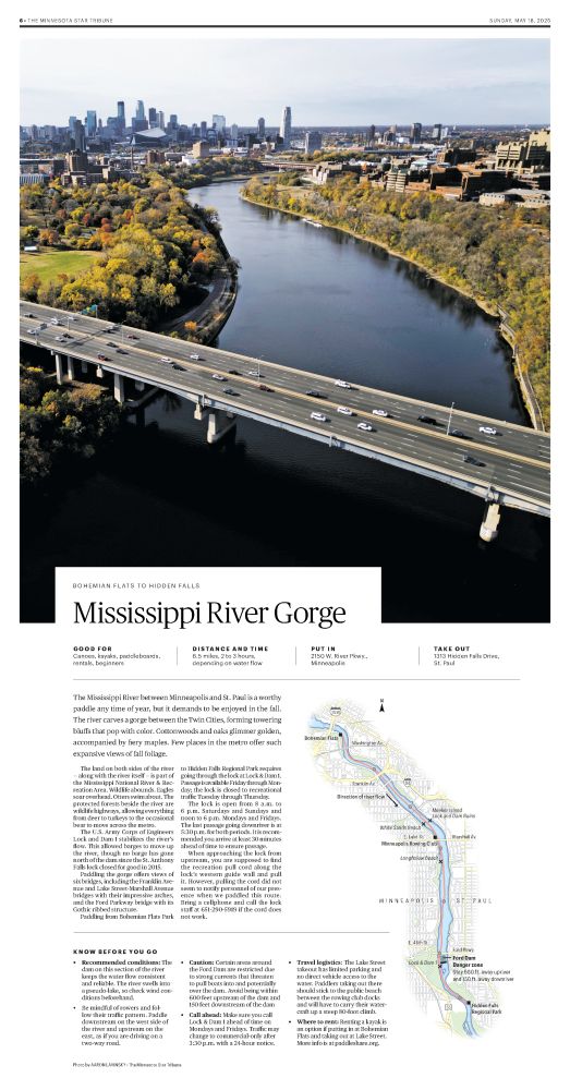
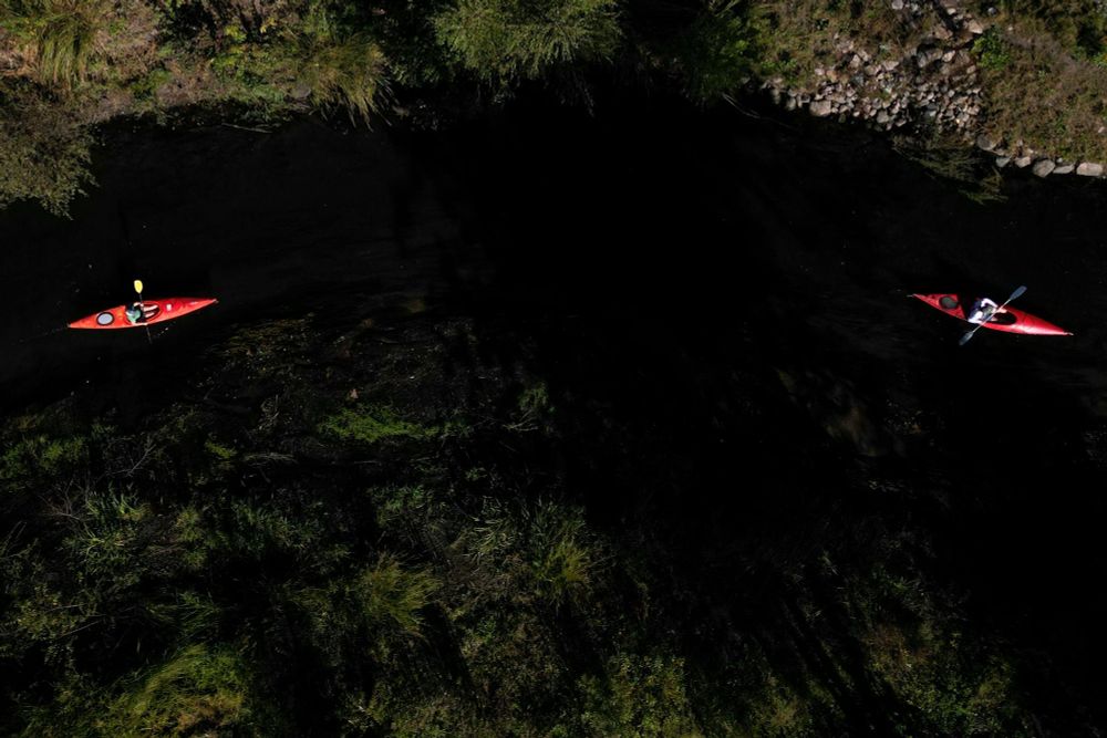
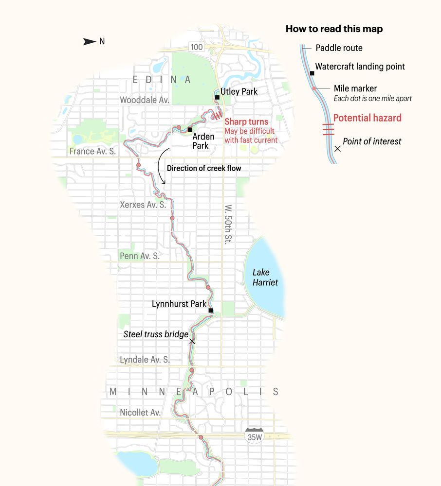
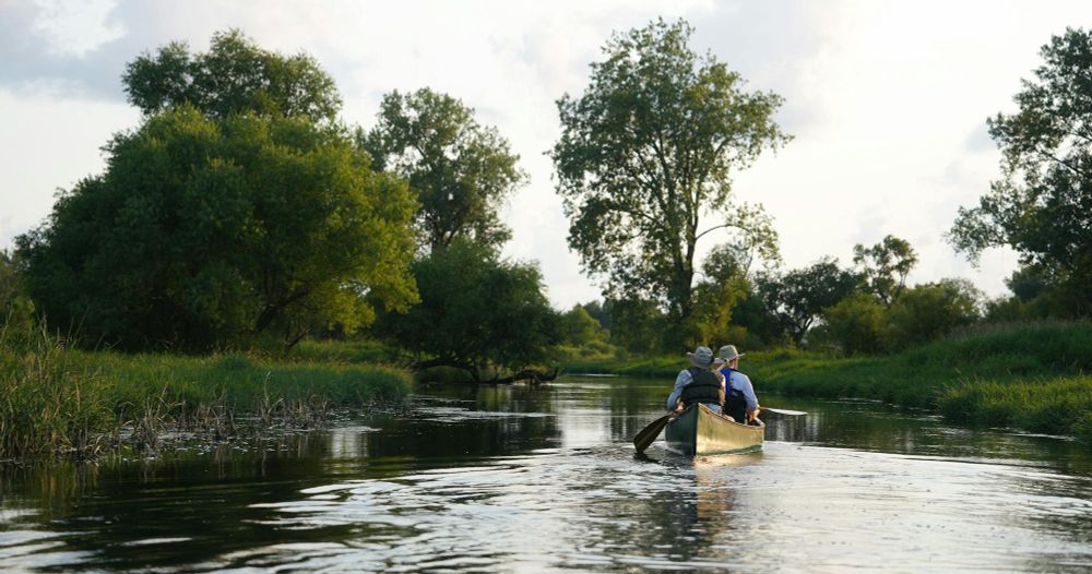
We spent an entire paddling season researching and paddling across the Twin Cities to create this guide. The Star Tribune has never put out a guide this comprehensive. Get out on the water, people. It's really the best thing you can do this summer.
www.startribune.com/canoe-kayak-...
www.startribune.com/canoe-kayak-...
May 19, 2025 at 3:17 PM
We spent an entire paddling season researching and paddling across the Twin Cities to create this guide. The Star Tribune has never put out a guide this comprehensive. Get out on the water, people. It's really the best thing you can do this summer.
www.startribune.com/canoe-kayak-...
www.startribune.com/canoe-kayak-...
Reposted by Adam Cox
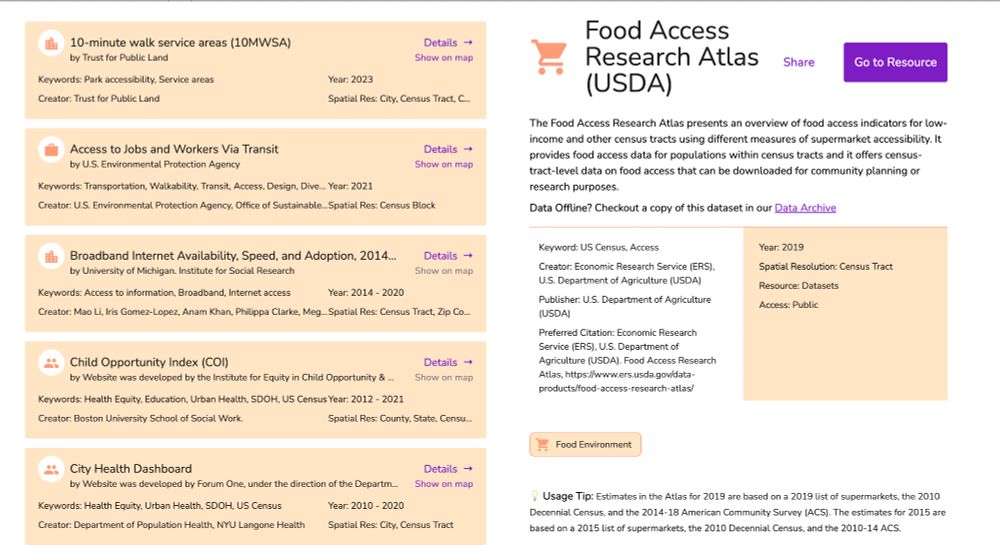
🚀 The SDOH & Place Project Data Discovery App Now LIVE! 📊🌍
To make finding #SDOH and place data easier, we present the SDOH & Place Data Discovery platform. Check out our Alpha release and provide feedback as we refine over the next few months. View the app live here: sdohplace.org/search
To make finding #SDOH and place data easier, we present the SDOH & Place Data Discovery platform. Check out our Alpha release and provide feedback as we refine over the next few months. View the app live here: sdohplace.org/search

March 18, 2025 at 6:57 PM
🚀 The SDOH & Place Project Data Discovery App Now LIVE! 📊🌍
To make finding #SDOH and place data easier, we present the SDOH & Place Data Discovery platform. Check out our Alpha release and provide feedback as we refine over the next few months. View the app live here: sdohplace.org/search
To make finding #SDOH and place data easier, we present the SDOH & Place Data Discovery platform. Check out our Alpha release and provide feedback as we refine over the next few months. View the app live here: sdohplace.org/search
Reposted by Adam Cox

DataLumos is an ICPSR archive for valuable government data resources. ICPSR has a long commitment to safekeeping and disseminating US government and other social science data. Learn more at datalumos.org.
#DataPreservation #OpenData #SocialScience
#DataPreservation #OpenData #SocialScience

March 18, 2025 at 1:43 PM
DataLumos is an ICPSR archive for valuable government data resources. ICPSR has a long commitment to safekeeping and disseminating US government and other social science data. Learn more at datalumos.org.
#DataPreservation #OpenData #SocialScience
#DataPreservation #OpenData #SocialScience
We plan to use @overturemaps.bsky.social Places data as reference layers in a soon-to-be-released web application, and I would love to link to more documentation about (and gain a better understanding of) the "confidence" field. Any pointers on where to look, beyond the official docs? #gischat
March 12, 2025 at 3:54 PM
We plan to use @overturemaps.bsky.social Places data as reference layers in a soon-to-be-released web application, and I would love to link to more documentation about (and gain a better understanding of) the "confidence" field. Any pointers on where to look, beyond the official docs? #gischat
#maplibrejs afficionados: Any way around this messy labeling? (numbers 32, 62, and 50) I'm thinking there isn't, as the label layer is on top of the cluster layer, and you can actually see the exact same behavior in the official docs example: maplibre.org/maplibre-gl-...

March 7, 2025 at 7:06 PM
#maplibrejs afficionados: Any way around this messy labeling? (numbers 32, 62, and 50) I'm thinking there isn't, as the label layer is on top of the cluster layer, and you can actually see the exact same behavior in the official docs example: maplibre.org/maplibre-gl-...
Reposted by Adam Cox
🚀 Data Discovery App 📊🔍
Easily explore datasets with structured metadata! To stay up-to-date, keep an eye on our socials, or sign up to our newsletter: go.illinois.edu/SDOH-SUBSCRIBE #MetadataMatters #DataDiscovery #SDOH #OpenData #FoodAccess #PublicHealth #CommunityPlanning
Easily explore datasets with structured metadata! To stay up-to-date, keep an eye on our socials, or sign up to our newsletter: go.illinois.edu/SDOH-SUBSCRIBE #MetadataMatters #DataDiscovery #SDOH #OpenData #FoodAccess #PublicHealth #CommunityPlanning
March 5, 2025 at 1:03 AM
🚀 Data Discovery App 📊🔍
Easily explore datasets with structured metadata! To stay up-to-date, keep an eye on our socials, or sign up to our newsletter: go.illinois.edu/SDOH-SUBSCRIBE #MetadataMatters #DataDiscovery #SDOH #OpenData #FoodAccess #PublicHealth #CommunityPlanning
Easily explore datasets with structured metadata! To stay up-to-date, keep an eye on our socials, or sign up to our newsletter: go.illinois.edu/SDOH-SUBSCRIBE #MetadataMatters #DataDiscovery #SDOH #OpenData #FoodAccess #PublicHealth #CommunityPlanning
Reposted by Adam Cox
Introducing the SDOH & Place Data Discovery App—helping users access key SDOH and health equity data from sources like CDC, PLACES, and Tree Canopy. 🚀 Alpha release coming soon! Stay updated via our socials or newsletter.https://go.illinois.edu/SDOH-SUBSCRIBE
#SDOH #PublicHealth #HealthEquity #Data
#SDOH #PublicHealth #HealthEquity #Data

February 25, 2025 at 9:22 PM
Introducing the SDOH & Place Data Discovery App—helping users access key SDOH and health equity data from sources like CDC, PLACES, and Tree Canopy. 🚀 Alpha release coming soon! Stay updated via our socials or newsletter.https://go.illinois.edu/SDOH-SUBSCRIBE
#SDOH #PublicHealth #HealthEquity #Data
#SDOH #PublicHealth #HealthEquity #Data
Newsletter finally out: oldinsurancemaps.net/news/2024-in..., also give a follow to the new account here: @oldinsurancemaps.net !
2024 in Review + new features! | OldInsuranceMaps.net
A crowdsourcing site for creating and viewing georeferenced mosaics of historical Sanborn fire insurance maps
oldinsurancemaps.net
February 21, 2025 at 6:33 PM
Newsletter finally out: oldinsurancemaps.net/news/2024-in..., also give a follow to the new account here: @oldinsurancemaps.net !
Reposted by Adam Cox

Thanks to @mradamcox.bsky.social for helping us set this up. Oldinsurancemaps.net is a easy platform for georeferencing with a group, especially those with minimal GIS experience.
OldInsuranceMaps.net
A crowdsourcing site for creating and viewing georeferenced mosaics of historical Sanborn fire insurance maps
Oldinsurancemaps.net
February 14, 2025 at 2:32 AM
Thanks to @mradamcox.bsky.social for helping us set this up. Oldinsurancemaps.net is a easy platform for georeferencing with a group, especially those with minimal GIS experience.
Reposted by Adam Cox

Missed our data preservation event yesterday? We've uploaded the entire discussion on our YouTube channel:
Federal data is disappearing. Meet the teams working to rescue it and learn how you can help.
Since the start of the new Trump administration, hundreds of federal data sets and government websites have gone offline without warning, sometimes returning...
youtu.be
February 14, 2025 at 6:44 PM
Missed our data preservation event yesterday? We've uploaded the entire discussion on our YouTube channel:
Reposted by Adam Cox
First Community Mapping Lab mapathon of the year! Digitizing Sanborn maps for Athens in 1918 for our historical work.


February 14, 2025 at 12:11 AM
First Community Mapping Lab mapathon of the year! Digitizing Sanborn maps for Athens in 1918 for our historical work.
Map-a-thon on OldInsuranceMaps.net going on right now by a group at UGA, georeferencing Athens, GA in 1918. It's fun to watch as the mosaic comes together: oldinsurancemaps.net/map/sanborn0... #sanbornmaps #crowdsource #georeferencing

February 14, 2025 at 12:10 AM
Map-a-thon on OldInsuranceMaps.net going on right now by a group at UGA, georeferencing Athens, GA in 1918. It's fun to watch as the mosaic comes together: oldinsurancemaps.net/map/sanborn0... #sanbornmaps #crowdsource #georeferencing