


MN Chaser
@mnchaser.bsky.social
Storm Chaser 🌪️ Landscape photography. NWS/Skywarn trained spotter. WI 🐄 raised. MN based. Primarily severe #mnwx and other climate topics. https://mnchaser.com
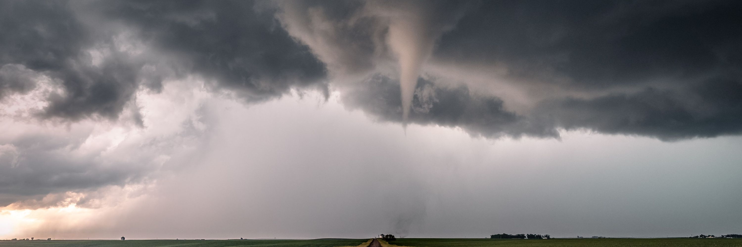
Wowza. That was fun. Radar measured 60mph+ here (20 miles from NWS). We got all of it. My weather station had debris up on it so I lost good reading. Power out in Prior Lake area. Neighbors sailboat flipped over. #mnwx
July 29, 2025 at 3:21 AM
Wowza. That was fun. Radar measured 60mph+ here (20 miles from NWS). We got all of it. My weather station had debris up on it so I lost good reading. Power out in Prior Lake area. Neighbors sailboat flipped over. #mnwx
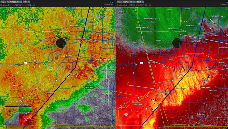
Line of strong storms moving east across the state. Looks like the muggy weather near the center of the state has helped maintain strength. #mnwx
June 2, 2025 at 10:56 PM
Line of strong storms moving east across the state. Looks like the muggy weather near the center of the state has helped maintain strength. #mnwx


May 15, 2025 at 11:09 AM
A HUGE Happy Mother's Day out there to all the moms!! 💙
May 11, 2025 at 6:57 PM
A HUGE Happy Mother's Day out there to all the moms!! 💙
A bit cooler today with this "Omega Block" like setup over CONUS. After today, we should finally see a period of consistent sunshine and mid-to-upper 70's! #mnwx

May 3, 2025 at 3:34 PM
A bit cooler today with this "Omega Block" like setup over CONUS. After today, we should finally see a period of consistent sunshine and mid-to-upper 70's! #mnwx
2024 was an active year of severe weather in the U.S. Especially within the "billion-dollar disasters" category.
www.climate.gov/news-feature...
#weather
www.climate.gov/news-feature...
#weather

2024: An active year of U.S. billion-dollar weather and climate disasters
With Hurricane Helene at the top of the list, there were 27 disasters in the United States in 2024 that individually cost $1 billion or more. It was the second-highest number since the NOAA record…
www.climate.gov
April 30, 2025 at 2:05 PM
2024 was an active year of severe weather in the U.S. Especially within the "billion-dollar disasters" category.
www.climate.gov/news-feature...
#weather
www.climate.gov/news-feature...
#weather
Reposted by MN Chaser

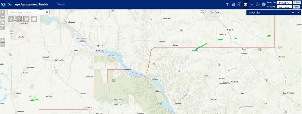
NWS Twin Cities is completing a survey of at least 5 tornadoes from Monday, April 28, 2025.
SE Rice County preliminary EF-1 TOR & 4 other TORs on the fringes of the service area south of Eau Claire.
NWS Green Bay had an addition 2 TORs east of Wausau.
#mnwx #wiwx #tornado @mpx.nws-bot.us
SE Rice County preliminary EF-1 TOR & 4 other TORs on the fringes of the service area south of Eau Claire.
NWS Green Bay had an addition 2 TORs east of Wausau.
#mnwx #wiwx #tornado @mpx.nws-bot.us
April 30, 2025 at 5:07 AM
NWS Twin Cities is completing a survey of at least 5 tornadoes from Monday, April 28, 2025.
SE Rice County preliminary EF-1 TOR & 4 other TORs on the fringes of the service area south of Eau Claire.
NWS Green Bay had an addition 2 TORs east of Wausau.
#mnwx #wiwx #tornado @mpx.nws-bot.us
SE Rice County preliminary EF-1 TOR & 4 other TORs on the fringes of the service area south of Eau Claire.
NWS Green Bay had an addition 2 TORs east of Wausau.
#mnwx #wiwx #tornado @mpx.nws-bot.us
I, unfortunately, had a lot of work to catch up on today and...darn it... sounds like I missed the productive discussion on the benefits of early warning and keeping the public safe from severe weather. 😅 #mnwx
April 30, 2025 at 5:38 AM
I, unfortunately, had a lot of work to catch up on today and...darn it... sounds like I missed the productive discussion on the benefits of early warning and keeping the public safe from severe weather. 😅 #mnwx
Ever wonder what Moderate - 15% actually means? Spoiler: it's not "15% chance of tornadoes". % needs to be compared against climatology %. For MN that's 1.00% today. So: 15% / 1% = 15x. "Forecasters believe it is 15x more likely than historical average day" #mnwx
www.mnchaser.com/learn/severe...
www.mnchaser.com/learn/severe...
Severe Weather - MNChaser
Astro description
www.mnchaser.com
April 28, 2025 at 12:46 PM
Ever wonder what Moderate - 15% actually means? Spoiler: it's not "15% chance of tornadoes". % needs to be compared against climatology %. For MN that's 1.00% today. So: 15% / 1% = 15x. "Forecasters believe it is 15x more likely than historical average day" #mnwx
www.mnchaser.com/learn/severe...
www.mnchaser.com/learn/severe...
For those chasing MN tomorrow - a kind reminder that it's construction season 🚧 with a handful of reduced lanes/closures (and people working)! Stay safe! #mnwx

April 27, 2025 at 6:04 PM
For those chasing MN tomorrow - a kind reminder that it's construction season 🚧 with a handful of reduced lanes/closures (and people working)! Stay safe! #mnwx
All ingredients present for widespread severe risk on Monday. Wondering how long discrete storms will last to the north before it QLCS's / linear. Down south, keeping an eye on the dry line and discrete cells capable of producing large tornadoes. #mnwx
April 27, 2025 at 12:21 PM
All ingredients present for widespread severe risk on Monday. Wondering how long discrete storms will last to the north before it QLCS's / linear. Down south, keeping an eye on the dry line and discrete cells capable of producing large tornadoes. #mnwx
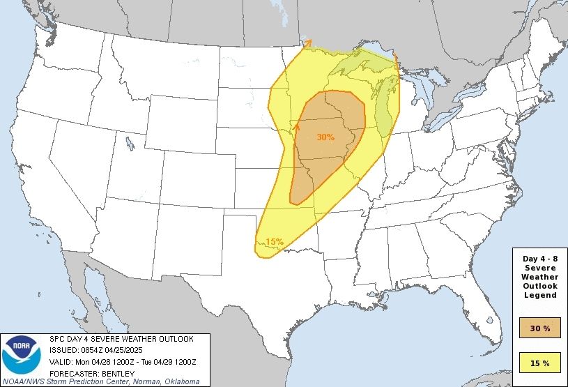
SPC Day 4 Outlook (Monday) ECMWF model 4pm timing of surface low and potential for another round of afternoon/evening severe storms. #mnwx

April 25, 2025 at 11:23 AM
SPC Day 4 Outlook (Monday) ECMWF model 4pm timing of surface low and potential for another round of afternoon/evening severe storms. #mnwx
Should come with a warning: won't shut up about weather.

April 25, 2025 at 5:00 AM
Should come with a warning: won't shut up about weather.
Reposted by MN Chaser

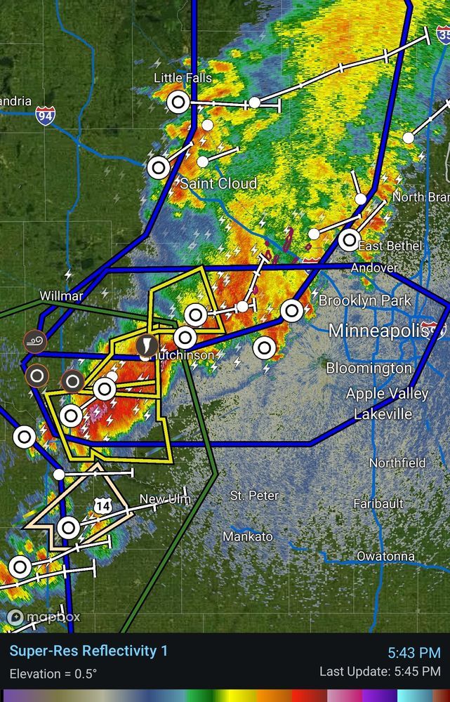
A cluster of severe storms is sprinting east at 60 mph this morning and has the potential to produce hail up to the size of ping pong balls.
These storms will reach the metro during rush hour.
These storms will reach the metro during rush hour.
April 18, 2025 at 10:46 AM
A cluster of severe storms is sprinting east at 60 mph this morning and has the potential to produce hail up to the size of ping pong balls.
These storms will reach the metro during rush hour.
These storms will reach the metro during rush hour.
Heading out for the first chase of the season...
April 17, 2025 at 8:32 PM
Heading out for the first chase of the season...
Reposted by MN Chaser

I’ve done 4 interviews in the last 24 hours about the reduction in balloon launches.
They’re starting to go live online.
www.notus.org/policy/weath...
They’re starting to go live online.
www.notus.org/policy/weath...

March 21, 2025 at 11:19 PM
I’ve done 4 interviews in the last 24 hours about the reduction in balloon launches.
They’re starting to go live online.
www.notus.org/policy/weath...
They’re starting to go live online.
www.notus.org/policy/weath...
I knew if I couldn't get down to the moisture, the best outcome would be 3 am bed time and a car wash. Glad I stayed back. Bummer.
March 15, 2025 at 12:01 AM
I knew if I couldn't get down to the moisture, the best outcome would be 3 am bed time and a car wash. Glad I stayed back. Bummer.
Reposted by MN Chaser

Here's your Spring Training 2025 SCHEDULE FOR THIS SATURDAY, MARCH 1! 🌪️⛈️🌈⚡️
This event is for EVERYONE so don't hesitate to get signed up.
ALL sessions and panels will be recorded this year!
We look forward to seeing you on Saturday! More info: girlswhochase.com/springtraining
This event is for EVERYONE so don't hesitate to get signed up.
ALL sessions and panels will be recorded this year!
We look forward to seeing you on Saturday! More info: girlswhochase.com/springtraining

February 25, 2025 at 1:04 AM
Here's your Spring Training 2025 SCHEDULE FOR THIS SATURDAY, MARCH 1! 🌪️⛈️🌈⚡️
This event is for EVERYONE so don't hesitate to get signed up.
ALL sessions and panels will be recorded this year!
We look forward to seeing you on Saturday! More info: girlswhochase.com/springtraining
This event is for EVERYONE so don't hesitate to get signed up.
ALL sessions and panels will be recorded this year!
We look forward to seeing you on Saturday! More info: girlswhochase.com/springtraining
Really enjoying the new pivotal weather beta on mobile/tablet. 👏🏻
February 25, 2025 at 1:18 AM
Really enjoying the new pivotal weather beta on mobile/tablet. 👏🏻
Long time in the making.... A much needed revamp of mnchaser.com is coming. Lightning fast loading, easier updates, and flexibility to embed a whole bunch of wx tools.
February 23, 2025 at 2:12 AM
Long time in the making.... A much needed revamp of mnchaser.com is coming. Lightning fast loading, easier updates, and flexibility to embed a whole bunch of wx tools.