


MapRVA
@maprva.org
Mappy Hours in Richmond, Virginia.
You can also find us in local-rva on the OSM US Slack.
🌉 bridged from https://en.osm.town/@maprva on the fediverse by https://fed.brid.gy/
You can also find us in local-rva on the OSM US Slack.
🌉 bridged from https://en.osm.town/@maprva on the fediverse by https://fed.brid.gy/
Reposted by MapRVA
RVA area peeps: @maprva.org will be leisurely cycling the new Henrico-Ashland portion of the Fall Line Trail next Saturday Nov 8.
We'd like YOU to join!
Plan is to meet behind the VCC Target ~11a, bike 7 mi to Ashland, eat, look at historic houses, and head back.
DM/reply for more details!
We'd like YOU to join!
Plan is to meet behind the VCC Target ~11a, bike 7 mi to Ashland, eat, look at historic houses, and head back.
DM/reply for more details!
November 1, 2025 at 3:21 PM
RVA area peeps: @maprva.org will be leisurely cycling the new Henrico-Ashland portion of the Fall Line Trail next Saturday Nov 8.
We'd like YOU to join!
Plan is to meet behind the VCC Target ~11a, bike 7 mi to Ashland, eat, look at historic houses, and head back.
DM/reply for more details!
We'd like YOU to join!
Plan is to meet behind the VCC Target ~11a, bike 7 mi to Ashland, eat, look at historic houses, and head back.
DM/reply for more details!
Reposted by MapRVA
Friendly reminder that our next meetup will be next Wed Oct 29th at Main Library, 6pm. We'll talk cemetery mapping! Including a presentation from Beth Zizzamia of the University of Richmond! In other words, it's going to be a good one 😀 hope to see you there!🎃 👻
October 21, 2025 at 9:10 PM
Friendly reminder that our next meetup will be next Wed Oct 29th at Main Library, 6pm. We'll talk cemetery mapping! Including a presentation from Beth Zizzamia of the University of Richmond! In other words, it's going to be a good one 😀 hope to see you there!🎃 👻
Friendly reminder that our next meetup will be next Wed Oct 29th at Main Library, 6pm. We'll talk cemetery mapping! Including a presentation from Beth Zizzamia of the University of Richmond! In other words, it's going to be a good one 😀 hope to see you there!🎃 👻
October 21, 2025 at 9:10 PM
Friendly reminder that our next meetup will be next Wed Oct 29th at Main Library, 6pm. We'll talk cemetery mapping! Including a presentation from Beth Zizzamia of the University of Richmond! In other words, it's going to be a good one 😀 hope to see you there!🎃 👻
Reposted by MapRVA
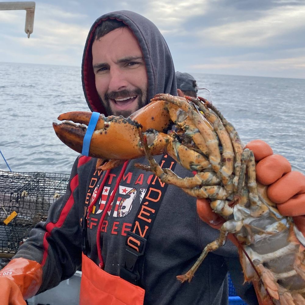
In fun hyper-local information and mapping, @maprva.org (@trailsta.sh) has mapped the RVA gun hole on @openhistoricalmap.org... and also added a page in @wikidatacommunity.bsky.social.
www.openhistoricalmap.org/node/2140307...
www.wikidata.org/wiki/Q136514...
www.openhistoricalmap.org/node/2140307...
www.wikidata.org/wiki/Q136514...
October 16, 2025 at 3:32 PM
In fun hyper-local information and mapping, @maprva.org (@trailsta.sh) has mapped the RVA gun hole on @openhistoricalmap.org... and also added a page in @wikidatacommunity.bsky.social.
www.openhistoricalmap.org/node/2140307...
www.wikidata.org/wiki/Q136514...
www.openhistoricalmap.org/node/2140307...
www.wikidata.org/wiki/Q136514...
Our next meetup is TONIGHT at 6pm, and it's VIRTUAL! Can't wait to see you.
https://cwm.zoom.us/j/87542434646
https://cwm.zoom.us/j/87542434646

Join our Cloud HD Video Meeting
Zoom is the leader in modern enterprise cloud communications.
cwm.zoom.us
October 9, 2025 at 7:01 PM
Our next meetup is TONIGHT at 6pm, and it's VIRTUAL! Can't wait to see you.
https://cwm.zoom.us/j/87542434646
https://cwm.zoom.us/j/87542434646
MapRVA has a lot in store for October! Visit maprva.org for more details. Hope to see you there 🗺️

October 6, 2025 at 5:58 PM
MapRVA has a lot in store for October! Visit maprva.org for more details. Hope to see you there 🗺️
We are proud to have our latest project, Georeference Tool, featured in the Church Hill Lookout!
https://www.chlookout.com/p/like-google-street-view-but-for-richmond-history
https://www.chlookout.com/p/like-google-street-view-but-for-richmond-history

Like Google Street View, but for Richmond history
Plus: Commemorating a century since the Church Hill Tunnel collapse!
www.chlookout.com
October 3, 2025 at 5:48 PM
We are proud to have our latest project, Georeference Tool, featured in the Church Hill Lookout!
https://www.chlookout.com/p/like-google-street-view-but-for-richmond-history
https://www.chlookout.com/p/like-google-street-view-but-for-richmond-history
What a fantastic first week of our Georeference Tool! We already have over 500 image georeferences across Richmond, and we're working on importing new datasets!
Our map viewer now allows you to sort by date, and overlay Sanborn insurance maps from the 1900s.
Check it out: georeference.maprva.org
Our map viewer now allows you to sort by date, and overlay Sanborn insurance maps from the 1900s.
Check it out: georeference.maprva.org

September 17, 2025 at 11:34 PM
What a fantastic first week of our Georeference Tool! We already have over 500 image georeferences across Richmond, and we're working on importing new datasets!
Our map viewer now allows you to sort by date, and overlay Sanborn insurance maps from the 1900s.
Check it out: georeference.maprva.org
Our map viewer now allows you to sort by date, and overlay Sanborn insurance maps from the 1900s.
Check it out: georeference.maprva.org
Reposted by MapRVA
Big day for me today. I have in my hands the my first published paper map!

September 4, 2025 at 3:08 PM
Big day for me today. I have in my hands the my first published paper map!
Lots to look forward to in September! Hope to see you this week at Main Library for some bus stop mapping. Check out our full calendar at maprva.org

September 2, 2025 at 3:27 AM
Lots to look forward to in September! Hope to see you this week at Main Library for some bus stop mapping. Check out our full calendar at maprva.org
Join us this Thursday, Aug 21st for some mapping fun in Carytown. Meet at New York Deli at 6pm!
https://osmcal.org/event/3982/
https://osmcal.org/event/3982/

MapRVA Carytown Meetup + Survey Trip!
MapRVA Carytown Meetup + Survey Trip!, 21st August 18:00 at New York Deli in Richmond, Virginia, United States. MapRVA is a meetup where cartography, GIS, and OpenStreetMap enthusiasts from the Richmond area meet…
osmcal.org
August 19, 2025 at 2:09 AM
Join us this Thursday, Aug 21st for some mapping fun in Carytown. Meet at New York Deli at 6pm!
https://osmcal.org/event/3982/
https://osmcal.org/event/3982/
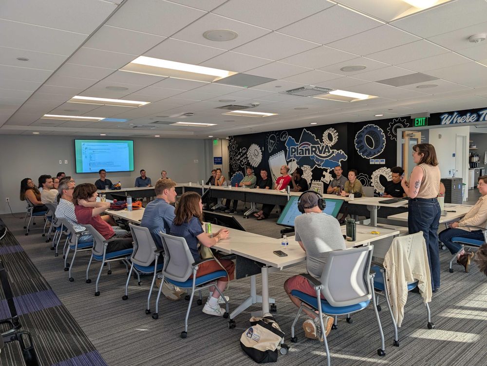
Our third and final event with PlanRVA will be this Thursday Aug 7 @ 6:30pm. Please click the link below to RSVP and see event details. Please bring a laptop if you'd like to participate in a group mapping sesh! […]
Original post on en.osm.town
en.osm.town
August 5, 2025 at 3:36 PM
Our third and final event with PlanRVA will be this Thursday Aug 7 @ 6:30pm. Please click the link below to RSVP and see event details. Please bring a laptop if you'd like to participate in a group mapping sesh! […]
Fantastic event tonight at PlanRVA. Thanks to everyone who came out and talked bike/ped infrastructure and the future of planning in RVA. Come join our next event on Aug 7, link below!
https://openstreetmap.app.neoncrm.com/nx/portal/neonevents/events?path=%2Fportal%2Fevents%2F20452
https://openstreetmap.app.neoncrm.com/nx/portal/neonevents/events?path=%2Fportal%2Fevents%2F20452
July 25, 2025 at 2:08 AM
Fantastic event tonight at PlanRVA. Thanks to everyone who came out and talked bike/ped infrastructure and the future of planning in RVA. Come join our next event on Aug 7, link below!
https://openstreetmap.app.neoncrm.com/nx/portal/neonevents/events?path=%2Fportal%2Fevents%2F20452
https://openstreetmap.app.neoncrm.com/nx/portal/neonevents/events?path=%2Fportal%2Fevents%2F20452
omg @stamen liked our talk 😊 https://stamen.com/stamen-at-state-of-the-map-us-2025/
The State of the Map US (SOTMUS) 2025 conference in Boston, MA was yet another fantastic gathering of cartographers, mappers, and map enthusiasts. Stamen was well-represented this year by Kelsey Taylor, Eric Brelsford, and Eric Rodenbeck.
We presented two talks on Stamen projects related to open source tooling with maps. Now that we’re back in the swing of things, we wanted to share some of the highlights from our time in Boston. (Note: we’ll update this post with video links from mentioned talks when released later this year.)
**Kelsey’s talk**
Kelsey presented about one of our core carto tools projects, Map GL Style Build (aka the build system). We use this open source tool in most of our cartography projects to expand families of map styles efficiently to cover all use cases. Check out our slides here and the project Github repo here.
**Eric’s talk**
Eric Brelsford presented about the graceful retirement of Map Stack, Stamen’s raster map stacking tool. Instead of sunsetting the tool altogether, we created Map Stack Stack, where users can dig into the 500k+ images created using Map Stack over its 10-year life. Check out Eric’s slides here.
### Presentations and conversations we enjoyed
As usual, there were many fascinating talks at this year’s conference. Thankfully, most of them are recorded so we can share them after the fact (or catch ones we missed the first time).
_Yuri talking about support for the globe projection in MapLibre_
We’re always interested in hearing the latest from our friends working on MapLibre development. Yuri Astrakhan and Bart Louwers shared many interesting updates on progress across their wide-ranging brief. Stamen uses MapLibre across several of our projects and most of our carto tools support MapLibre GL.
_KartaVision finding all the black cat sightings on streetview images in Singapore_
We were also fascinated by KartaVision from Grab, a tool which crowdsources streetview imagery and uses AI to identify searchable items in each image. The level of detail here is impressive – we’re excited to see what this technology and data will unlock for historically undermapped areas.
It’s always great to hear how people interact with maps in the physical world, especially with the enthusiasm Andrew Middleton brings to the table. Hearing the ebbs and flows of owning a brick and mortar map store definitely makes us appreciate how easy working in the digital space is by comparison. It was also fun to pore over the newest book for sale at The Map Center, Damian Saunder’s Maps on Vinyl (which one of us may have purchased) in person.
We were really impressed by the OSM Tagger tool from the Humanitarian OpenStreetMap Team, which mixes WhatsApp and AI to create an interface that allows people to easily upload geotagged imagery and describe what’s in it. We’ve long been interested in making it easier for people to contribute to OpenStreetMap, with projects like Field Papers that let you gather geo-tagged information about places using the low-tech medium of QR-encoded printouts on paper. OSM Tagger feels like a modern successor to Field Papers, radically improving the ability of people with very little technical experience to contribute meaningfully to the mapping of their world, using hardware and software that’s already in their pockets.
A few other talks that are worth checking out once videos are posted:
* The other streets: adding NYC Honorary Street Names to visualize communities, on mapping honorary street names in a particular neighborhood in Manhattan and the stories behind those names
* How we mapped the Richmond Water Crisis, about a crowdsourced map where people could report their water status in Richmond during its recent water crisis
### Stamens old and new!
One of the best things about SOTMUS is the community; for all that it’s grown and changed over the years, the geospatial industry around OpenStreetMap is still small enough that you can know many people in it and feel like you’re part of something human. Stamen’s been around for a minute, and it was great to gather current Stamens (some of us around longer than others) to spend time with alums like Mike Migurski and share common experiences over the years.
### Until next time
We thoroughly enjoyed the variety of practical and technical presentations at this year’s SOTMUS. It’s always wonderful to spend time with other people in the geo community who are passionate about open source data and tooling. We’re already looking forward to next year — hope to see you there!
stamen.com
July 16, 2025 at 6:23 PM
omg @stamen liked our talk 😊 https://stamen.com/stamen-at-state-of-the-map-us-2025/
#introduction
MapRVA is a small group of #mapping & #OpenStreetMap enthusiasts in Richmond, Virginia #rva
We meet every few weeks.
You can find us on the @OpenStreetMapUS #slack instance in the local-rva channel.
MapRVA is a small group of #mapping & #OpenStreetMap enthusiasts in Richmond, Virginia #rva
We meet every few weeks.
You can find us on the @OpenStreetMapUS #slack instance in the local-rva channel.
June 26, 2025 at 1:17 AM
#introduction
MapRVA is a small group of #mapping & #OpenStreetMap enthusiasts in Richmond, Virginia #rva
We meet every few weeks.
You can find us on the @OpenStreetMapUS #slack instance in the local-rva channel.
MapRVA is a small group of #mapping & #OpenStreetMap enthusiasts in Richmond, Virginia #rva
We meet every few weeks.
You can find us on the @OpenStreetMapUS #slack instance in the local-rva channel.