


Dragons8mycat
@dragons8mycat.bsky.social
The original Geoninja.
Curious about where this #GIS thing is going....
All thoughts and opinions are my own.
Curious about where this #GIS thing is going....
All thoughts and opinions are my own.

April 13, 2025 at 8:37 PM
Been quiet recently, but the announcement has been made, so I can talk about it!
GB Local Plan and SHLAA data now available....
#gis #geo #gischat
www.linkedin.com/posts/dragon...
GB Local Plan and SHLAA data now available....
#gis #geo #gischat
www.linkedin.com/posts/dragon...

Nicholas Duggan FRGS CGeog (GIS) on LinkedIn: Idox Local Plans - Emapsite
It's been a long time coming, but believe me, it was worth the wait!
www.linkedin.com
March 7, 2025 at 7:33 PM
Been quiet recently, but the announcement has been made, so I can talk about it!
GB Local Plan and SHLAA data now available....
#gis #geo #gischat
www.linkedin.com/posts/dragon...
GB Local Plan and SHLAA data now available....
#gis #geo #gischat
www.linkedin.com/posts/dragon...
Is data engineering dying?
Interesting read, and thinking where Google, Airbus and other companies are right now, this could be the future.
#GIS
medium.com/@shenoy.shas...
Interesting read, and thinking where Google, Airbus and other companies are right now, this could be the future.
#GIS
medium.com/@shenoy.shas...

Is Data Engineering Dying? The AI Takeover & The Future of Data Roles!
For years, Data Engineers have been the Architects of scalable, robust Data pipelines. But with AI-driven automation making its way into…
medium.com
February 27, 2025 at 8:36 AM
Is data engineering dying?
Interesting read, and thinking where Google, Airbus and other companies are right now, this could be the future.
#GIS
medium.com/@shenoy.shas...
Interesting read, and thinking where Google, Airbus and other companies are right now, this could be the future.
#GIS
medium.com/@shenoy.shas...
Reposted by Dragons8mycat

PostgreSQL 17.4, 16.8, 15.12, 14.17, and 13.20 Released

PostgreSQL 17.4, 16.8, 15.12, 14.17, and 13.20 Released!
The PostgreSQL Global Development Group has released an update to all supported versions of PostgreSQL, including 17.4, 16.8, 15.12, 14.17, …
www.postgresql.org
February 21, 2025 at 8:52 AM
PostgreSQL 17.4, 16.8, 15.12, 14.17, and 13.20 Released
10years ago I set up an #AIS and #ADSB system with an antenna, an open source NMEA decoder and a simple SQL database costing less than £1000 to capture live data for shipping and aviation
Apparently now I need a whole #Esri #GIS solution:
www.esri.com/en-us/indust...
Apparently now I need a whole #Esri #GIS solution:
www.esri.com/en-us/indust...

Taking Flight: Real-Time Aircraft Tracking with ArcGIS Velocity and FlightAware
FlightAware and ArcGIS Velocity enable real-time aircraft tracking, alerts, and analysis for safer, smarter emergency response.
www.esri.com
February 21, 2025 at 8:48 AM
10years ago I set up an #AIS and #ADSB system with an antenna, an open source NMEA decoder and a simple SQL database costing less than £1000 to capture live data for shipping and aviation
Apparently now I need a whole #Esri #GIS solution:
www.esri.com/en-us/indust...
Apparently now I need a whole #Esri #GIS solution:
www.esri.com/en-us/indust...
Would love to see how this works for local coordinate systems ( #CAD users will know!) #GIS
Geolocate CAD and BIM from the start (@Esri)
www.esri.com/arcgis-blog/...
Geolocate CAD and BIM from the start (@Esri)
www.esri.com/arcgis-blog/...

Geolocate CAD and BIM files from the start: Strategies and Resources
AutoCAD, Revit, Integration, Geospatial, Civil 3D, geolocation, digital model, esri, ArcGIS Pro, ArcGIS
www.esri.com
February 21, 2025 at 8:42 AM
Would love to see how this works for local coordinate systems ( #CAD users will know!) #GIS
Geolocate CAD and BIM from the start (@Esri)
www.esri.com/arcgis-blog/...
Geolocate CAD and BIM from the start (@Esri)
www.esri.com/arcgis-blog/...
Updated #AI in #GlobalMapper?
I've got a secret crush on this #GIS, does some great things
dronelife.com/2025/02/19/g...
I've got a secret crush on this #GIS, does some great things
dronelife.com/2025/02/19/g...

Global Mapper v26.1 Enhances AI-Based Tools and User Experience
Global Mapper v26.1 introduces AI-powered deep learning enhancements, improved point cloud processing, and streamlined user tools.
dronelife.com
February 20, 2025 at 9:55 AM
Updated #AI in #GlobalMapper?
I've got a secret crush on this #GIS, does some great things
dronelife.com/2025/02/19/g...
I've got a secret crush on this #GIS, does some great things
dronelife.com/2025/02/19/g...
#intertialnavigation #quantumnavigation and #LondonUnderground all in one #geospatial blog!
www.thenakedscientists.com/articles/int...
www.thenakedscientists.com/articles/int...

Tracking trains with quantum mechanics
Mind the quantum gap...
www.thenakedscientists.com
February 17, 2025 at 10:57 AM

If you know of a #projection connection that's missing from the poster, please let me know! I would like to expand it at some point.
(Also it's free to download and if anyone's ever printed it out in the last couple of years I'd be keen to know!)
somethingaboutmaps.wordpress.com/2022/12/19/p...
(Also it's free to download and if anyone's ever printed it out in the last couple of years I'd be keen to know!)
somethingaboutmaps.wordpress.com/2022/12/19/p...
February 17, 2025 at 9:30 AM
One of the most devisive and scariest #GIS blogs I have ever read:
learn.g2.com/best-gis-sof...
TLDR: AutoCAD is on the list!
#GISChat
learn.g2.com/best-gis-sof...
TLDR: AutoCAD is on the list!
#GISChat

I Compared 6 GIS Software to Find the Best for Mapping
Here is my analysis of 6 best GIS software in 2025 to remote manage geographical projects, design disaster management workflows, and optimize risk handling.
learn.g2.com
February 17, 2025 at 9:20 AM
One of the most devisive and scariest #GIS blogs I have ever read:
learn.g2.com/best-gis-sof...
TLDR: AutoCAD is on the list!
#GISChat
learn.g2.com/best-gis-sof...
TLDR: AutoCAD is on the list!
#GISChat
Breaking news....
The UK #AI Safety Institute becomes the UK AI Security Institute, you heard it here first 😂
www.ukauthority.com/articles/ai-...
The UK #AI Safety Institute becomes the UK AI Security Institute, you heard it here first 😂
www.ukauthority.com/articles/ai-...

AI Safety Institute becomes AI Security Institute | UKAuthority
www.ukauthority.com
February 14, 2025 at 10:57 AM
Breaking news....
The UK #AI Safety Institute becomes the UK AI Security Institute, you heard it here first 😂
www.ukauthority.com/articles/ai-...
The UK #AI Safety Institute becomes the UK AI Security Institute, you heard it here first 😂
www.ukauthority.com/articles/ai-...

February 2, 2025 at 11:26 AM
#FOSS #OpenSource Esri Leaflet?
Anyone of my friends tried this?
developers.arcgis.com/esri-leaflet/
#GIS #Geo
Anyone of my friends tried this?
developers.arcgis.com/esri-leaflet/
#GIS #Geo

Esri Leaflet | Esri Developer
developers.arcgis.com
January 31, 2025 at 8:56 AM
#FOSS #OpenSource Esri Leaflet?
Anyone of my friends tried this?
developers.arcgis.com/esri-leaflet/
#GIS #Geo
Anyone of my friends tried this?
developers.arcgis.com/esri-leaflet/
#GIS #Geo
Making a simple #AI #GeoAI Leaflet #map which gives informaiton on where you click
#GIS #Geo
www.youtube.com/watch?v=UKjw...
#GIS #Geo
www.youtube.com/watch?v=UKjw...

Generate Location Descriptions with the Google Gemini API
YouTube video by Courtney Yatteau
www.youtube.com
January 31, 2025 at 8:49 AM

How #Spatial computing is shaping our #geospatial future....gret talk from @OrdnanceSurvey CEO
#GIS #Geospatial
geospatialworld.net/videos/spati...
#GIS #Geospatial
geospatialworld.net/videos/spati...

How Spatial Computing is Shaping the Geospatial Future
Discover how AI, ML, and spatial computing are transforming geospatial technology. Nick Bolton, CEO of Ordnance Survey, shares insights on optimizing the geospatial value chain and the power of cross-...
geospatialworld.net
January 28, 2025 at 9:14 AM
How #Spatial computing is shaping our #geospatial future....gret talk from @OrdnanceSurvey CEO
#GIS #Geospatial
geospatialworld.net/videos/spati...
#GIS #Geospatial
geospatialworld.net/videos/spati...
Wow, this is a heartbreaking map. thanks for sharing @robininatree.bsky.social


By compiling multiple sources of data, we reach the astonishing figure of 71,000 migrants who have died or been missing at the European border since the early 90s. A hecatomb caused by the migration policies of European countries.
January 24, 2025 at 9:27 AM
Wow, this is a heartbreaking map. thanks for sharing @robininatree.bsky.social
Did you know that there was a world leading company building satellites in Guildford, #UK? I met them a few years ago when they were talking about #GNSSS on the moon....
...well, they are now opening a new optical cleanroom for better #EO sensors...
www.machinery-market.co.uk/news/39026/S...
...well, they are now opening a new optical cleanroom for better #EO sensors...
www.machinery-market.co.uk/news/39026/S...

SSTL opens ‘state of the art’ optical imaging cleanroom - MM Media
UK Space Agency CEO Dr Paul Bate (centre) with SSTL managing director Andrew Cawthorne (left) and SSTL chairman Sir Martin Sweeting (right)Surrey Satellite Technology Ltd (SSTL) has officially opened ...
www.machinery-market.co.uk
January 24, 2025 at 9:08 AM
Did you know that there was a world leading company building satellites in Guildford, #UK? I met them a few years ago when they were talking about #GNSSS on the moon....
...well, they are now opening a new optical cleanroom for better #EO sensors...
www.machinery-market.co.uk/news/39026/S...
...well, they are now opening a new optical cleanroom for better #EO sensors...
www.machinery-market.co.uk/news/39026/S...
#UK leading the west in #PNT, #Quantum and #eLoran?....
www.gpsworld.com/uk-leading-t...
#gnss #gis #gischat
www.gpsworld.com/uk-leading-t...
#gnss #gis #gischat

UK leading the West in PNT with clocks, eLoran and quantum research - GPS World
Saying the government must focus on “delivering an operational resilient positioning, navigation and timing (PNT) system for the United Kingdom as soon as we can,” the British Science Minister, Lord P...
www.gpsworld.com
January 23, 2025 at 8:23 PM

January 22, 2025 at 11:47 AM
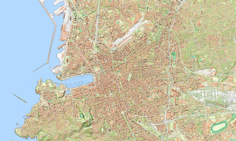
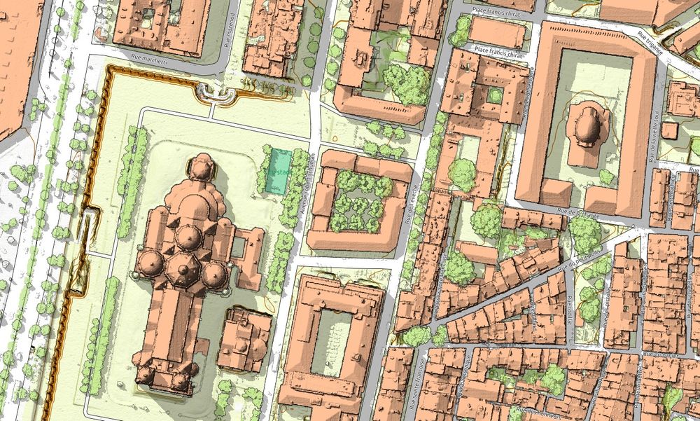
Reposted by Dragons8mycat

The new map of Marseille is ready !
↪️ jgaffuri.github.io/CartoHD_webm...
#map #maps #lidar #cartography #gis #gischat #mapart #dataviz #marseille
↪️ jgaffuri.github.io/CartoHD_webm...
#map #maps #lidar #cartography #gis #gischat #mapart #dataviz #marseille
January 19, 2025 at 8:45 PM
The new map of Marseille is ready !
↪️ jgaffuri.github.io/CartoHD_webm...
#map #maps #lidar #cartography #gis #gischat #mapart #dataviz #marseille
↪️ jgaffuri.github.io/CartoHD_webm...
#map #maps #lidar #cartography #gis #gischat #mapart #dataviz #marseille
Booming #3DGIS market?.....15yrs specialising in 3D #GIS and it is yet to be the default for data and projects, even though almost all data is now captured with vertical elements:
www.openpr.com/news/3822046...
www.openpr.com/news/3822046...

Booming 3D Mapping And Modeling Market: Unveiling Growth Drivers, Key Players, and Future Trends
Spearheaded by Rapid Urbanization GIS Applications and Advanced Computer Graphics Discover the 3D Mapping and Modeling Market s Potential What Is The Projected Market Size Of The Global 3D Mapping And...
www.openpr.com
January 21, 2025 at 8:56 AM
Booming #3DGIS market?.....15yrs specialising in 3D #GIS and it is yet to be the default for data and projects, even though almost all data is now captured with vertical elements:
www.openpr.com/news/3822046...
www.openpr.com/news/3822046...

