


Antonio J. Castañeda-Gómez
@antoniocastaneda.bsky.social
Geologist & Remote Sensing Scientist | Earth Observation Research Cluster, Uni Würzburg 🌍🔍 @eor-wuerzburg.bsky.social
UAS Lecturer | Member of the UAS Team 🚀
PhD Researcher on Environmental & Forestry Applications of UAS 🌿📡
UAS Lecturer | Member of the UAS Team 🚀
PhD Researcher on Environmental & Forestry Applications of UAS 🌿📡
Reposted by Antonio J. Castañeda-Gómez

After the fieldwork ist before the fieldwork - @antoniocastaneda.bsky.social working on #uas research hardware preparation in #africa

August 7, 2025 at 9:29 AM
After the fieldwork ist before the fieldwork - @antoniocastaneda.bsky.social working on #uas research hardware preparation in #africa
Reposted by Antonio J. Castañeda-Gómez

Reposted by Antonio J. Castañeda-Gómez
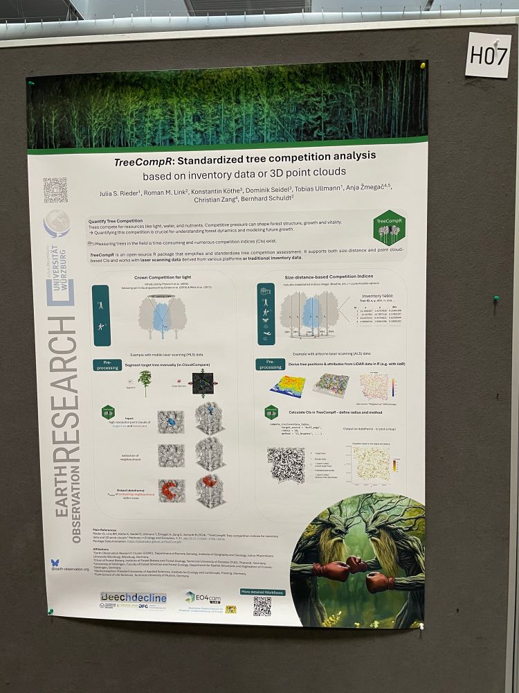
Are you working with LiDAR or inventory data? Visit me at poster H07 at #LPS25 to find out more about our R package, TreeCompR, which provides solutions for quantifying tree competition!
June 27, 2025 at 7:07 AM
Are you working with LiDAR or inventory data? Visit me at poster H07 at #LPS25 to find out more about our R package, TreeCompR, which provides solutions for quantifying tree competition!
Swing by my poster today at the #LPS25!
Excited to share some of our work at the UAS Team, @earth-observation.org ! We’ve been exploring the comparability between UAV-based datasets and Sentinel-2.
@schwalb-willmann.de @bevanda.bsky.social
Excited to share some of our work at the UAS Team, @earth-observation.org ! We’ve been exploring the comparability between UAV-based datasets and Sentinel-2.
@schwalb-willmann.de @bevanda.bsky.social
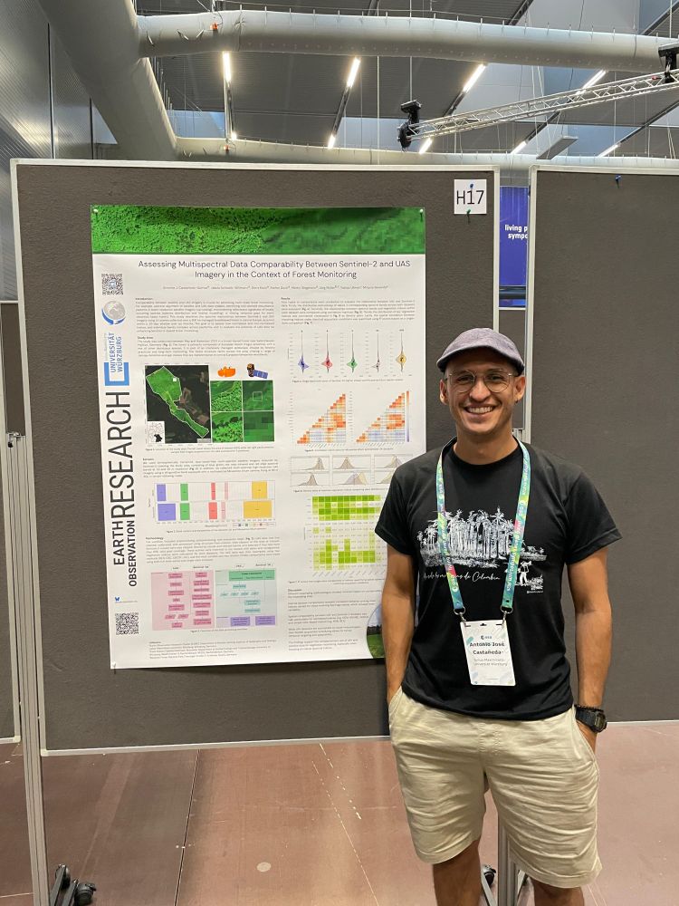
June 27, 2025 at 7:16 AM
Swing by my poster today at the #LPS25!
Excited to share some of our work at the UAS Team, @earth-observation.org ! We’ve been exploring the comparability between UAV-based datasets and Sentinel-2.
@schwalb-willmann.de @bevanda.bsky.social
Excited to share some of our work at the UAS Team, @earth-observation.org ! We’ve been exploring the comparability between UAV-based datasets and Sentinel-2.
@schwalb-willmann.de @bevanda.bsky.social

Reposted by Antonio J. Castañeda-Gómez
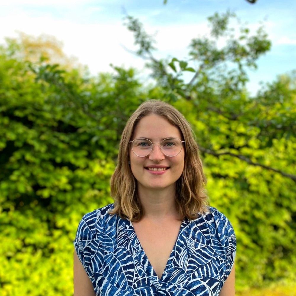
our #PhDchat Julia Rieder is presenting her #earthobservation research on drought in orchard meadows at ESA #LPS25 - drop by and chat with her about her work on #tree #forest #meadow #remotesensing #eochat

June 26, 2025 at 11:01 AM
our #PhDchat Julia Rieder is presenting her #earthobservation research on drought in orchard meadows at ESA #LPS25 - drop by and chat with her about her work on #tree #forest #meadow #remotesensing #eochat
Reposted by Antonio J. Castañeda-Gómez
our #PhD student Elio Rauth is presenting at ESA #LPS25 our research on #Svalbard using #UAS #UAV #multispectral #thermal #lidar systems with @antoniocastaneda.bsky.social @schwalb-willmann.de @bevanda.bsky.social @larissabeumer.bsky.social and our EAGLE students Ronja, Lena and Jannis

June 26, 2025 at 11:04 AM
our #PhD student Elio Rauth is presenting at ESA #LPS25 our research on #Svalbard using #UAS #UAV #multispectral #thermal #lidar systems with @antoniocastaneda.bsky.social @schwalb-willmann.de @bevanda.bsky.social @larissabeumer.bsky.social and our EAGLE students Ronja, Lena and Jannis
Excited to see our UAV work in Svalbard featured at #LPS25! We used fixed-wing drones with multispectral sensors to study high-latitude vegetation in one of the world’s most remote and fragile regions. Huge thanks to Elio Rauth and the IAS team at the @earth-observation.org

June 26, 2025 at 10:48 AM
Excited to see our UAV work in Svalbard featured at #LPS25! We used fixed-wing drones with multispectral sensors to study high-latitude vegetation in one of the world’s most remote and fragile regions. Huge thanks to Elio Rauth and the IAS team at the @earth-observation.org
Reposted by Antonio J. Castañeda-Gómez
great group picture of our EORC staff and EAGLEs at ESA #LPS25 - a fantastic week with plenty of interesting discussions, talks and posters! #earthobs #eochat #remotesensing
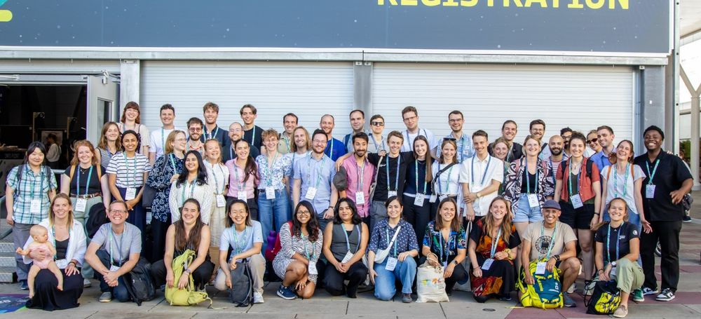
June 26, 2025 at 10:11 AM
great group picture of our EORC staff and EAGLEs at ESA #LPS25 - a fantastic week with plenty of interesting discussions, talks and posters! #earthobs #eochat #remotesensing
Catch me & @annabischof.bsky.social at tonight’s #LPS25 poster session in Vienna! We're presenting our work with Nature Seychelles & @earth-observation.org on RGB drones for mangrove monitoring. Marlene Bauer can't join, but her input was key. Excited to connect! #UAV #Ecology #RemoteSensing
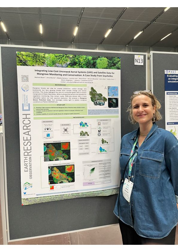
June 24, 2025 at 12:58 PM
Catch me & @annabischof.bsky.social at tonight’s #LPS25 poster session in Vienna! We're presenting our work with Nature Seychelles & @earth-observation.org on RGB drones for mangrove monitoring. Marlene Bauer can't join, but her input was key. Excited to connect! #UAV #Ecology #RemoteSensing
Reposted by Antonio J. Castañeda-Gómez
Want to do #remotesensing analysis using #rspatial and derive classifications, vegetation indices, spectral unmixing, fractional cover, preprocessing .... ? check out #RStoolbox #rstats - anything missing? Let us know! @caipide.bsky.social @schwalb-willmann.de
remote-sensing.org/exploring-th...
remote-sensing.org/exploring-th...

Exploring the Power of Satellite Remote Sensing with the RStoolbox R Package
Satellite remote sensing has become an indispensable tool for monitoring the Earth's surface, offering a unique perspective on environmental changes across spac
remote-sensing.org
February 8, 2025 at 11:28 AM
Want to do #remotesensing analysis using #rspatial and derive classifications, vegetation indices, spectral unmixing, fractional cover, preprocessing .... ? check out #RStoolbox #rstats - anything missing? Let us know! @caipide.bsky.social @schwalb-willmann.de
remote-sensing.org/exploring-th...
remote-sensing.org/exploring-th...
Reposted by Antonio J. Castañeda-Gómez

Grateful that I could work on using animals for Earth observation at @uni-wuerzburg.de, in cooperation with @dlr-de.bsky.social & @mpi-animalbehav.bsky.social. Many thanks to my supervisors & mentors Stefan Dech, Martin Wikelski, Tobias Ullmann & Martin Wegmann & everyone @eor-wuerzburg.bsky.social!

April 8, 2025 at 9:54 AM
Grateful that I could work on using animals for Earth observation at @uni-wuerzburg.de, in cooperation with @dlr-de.bsky.social & @mpi-animalbehav.bsky.social. Many thanks to my supervisors & mentors Stefan Dech, Martin Wikelski, Tobias Ullmann & Martin Wegmann & everyone @eor-wuerzburg.bsky.social!
Planning a hyperspectral drone mission in steep terrain, I ran into the usual issue: flying too close to the slope due to poor AGL handling. I built SMARTAGL, an R tool that creates terrain-aware flight lines with constant AGL. Open-source & field-tested. (github.com/ajcastanedag...)
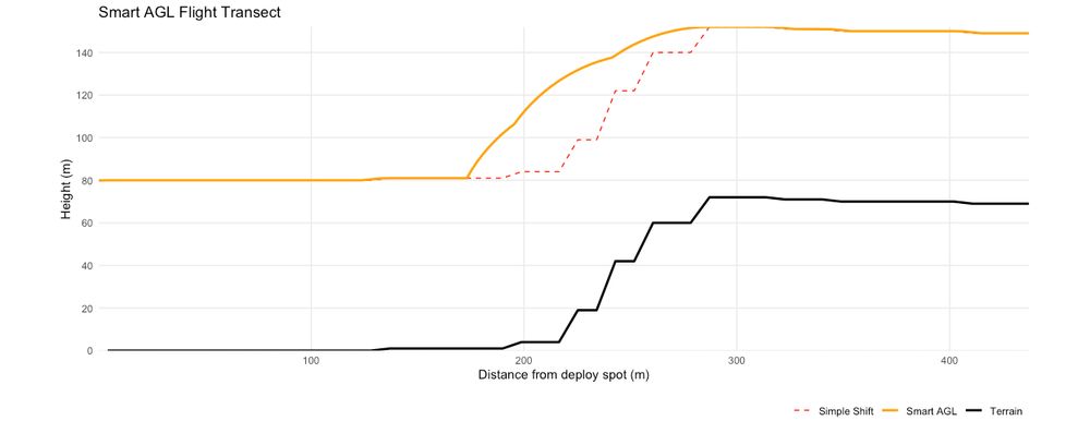
May 21, 2025 at 1:34 PM
Planning a hyperspectral drone mission in steep terrain, I ran into the usual issue: flying too close to the slope due to poor AGL handling. I built SMARTAGL, an R tool that creates terrain-aware flight lines with constant AGL. Open-source & field-tested. (github.com/ajcastanedag...)