


Ambrogio Volonté
@ambroeusvolonte.bsky.social
Senior Research Fellow @ Uni of Reading Meteorology & NCAS | Sting jets💨 Cyclones (Arctic, Extratropical, Mediterranean....) 🌀 Alps🏔 Monsoons⛈️| Cycling,hiking & views all my own| Catholic, husband, dad, son
8 days left to apply!
Interested in revealing how moisture-driven surface cyclones can develop into hazardous windstorms, now and in the future? You could do it at @unirdg-met.bsky.social @ncas-uk.bsky.social, working with @benharvey.bsky.social, @jriboldi.bsky.social, Sue gray and me!
jobs.reading.ac.uk/Job/JobDetai...
jobs.reading.ac.uk/Job/JobDetai...
Research Scientist (North Atlantic Storms and Climate Change):Whiteknights Reading UK
The closing date for applications is 23.59 on 21 November 2025
jobs.reading.ac.uk
November 13, 2025 at 10:25 AM
8 days left to apply!
Are you investigating the role of "Diabatic processes across scales in the extratropics"?this? Do you want to know more about it? There's a workshop for you! diabatics2026.w.uib.no We have a great invited speakers line-up (despite me being one...).
Deadline for abstract submission is tomorrow!
Deadline for abstract submission is tomorrow!
Diabatics 2026 workshop – Wolkersdorf, near Vienna, Austria, 28 April – 1 May 2026
The workshop is jointly organized under the auspices of the Working Group on Predictability, Dynamics and Ensemble Forecasting of the WMO’s World Weather Research Programme and the International Commission on Dynamic Meteorology of the International Association of Meteorology and Atmospheric Sciences.
diabatics2026.w.uib.no
October 31, 2025 at 12:03 PM
Are you investigating the role of "Diabatic processes across scales in the extratropics"?this? Do you want to know more about it? There's a workshop for you! diabatics2026.w.uib.no We have a great invited speakers line-up (despite me being one...).
Deadline for abstract submission is tomorrow!
Deadline for abstract submission is tomorrow!
Interested in revealing how moisture-driven surface cyclones can develop into hazardous windstorms, now and in the future? You could do it at @unirdg-met.bsky.social @ncas-uk.bsky.social, working with @benharvey.bsky.social, @jriboldi.bsky.social, Sue gray and me!
jobs.reading.ac.uk/Job/JobDetai...
jobs.reading.ac.uk/Job/JobDetai...
Research Scientist (North Atlantic Storms and Climate Change):Whiteknights Reading UK
The closing date for applications is 23.59 on 21 November 2025
jobs.reading.ac.uk
October 31, 2025 at 11:56 AM
Interested in revealing how moisture-driven surface cyclones can develop into hazardous windstorms, now and in the future? You could do it at @unirdg-met.bsky.social @ncas-uk.bsky.social, working with @benharvey.bsky.social, @jriboldi.bsky.social, Sue gray and me!
jobs.reading.ac.uk/Job/JobDetai...
jobs.reading.ac.uk/Job/JobDetai...
Really looking forward to the panel discussion with
Prof Ros Cornforth (Walker Centre, Uni of Reading)
Prof Sir Brian Hoskins (Uni of Reading & Imperial College London)
Dr Ben Wilson (Scottish Catholic International Aid Fund) taking place @ Corpus Christi College, Oxford at 10.30 am tomorrow (1/4)
Prof Ros Cornforth (Walker Centre, Uni of Reading)
Prof Sir Brian Hoskins (Uni of Reading & Imperial College London)
Dr Ben Wilson (Scottish Catholic International Aid Fund) taking place @ Corpus Christi College, Oxford at 10.30 am tomorrow (1/4)

Convergence
FREE AND OPEN TO EVERYONE
convergenceuk.org
March 28, 2025 at 4:03 PM
Really looking forward to the panel discussion with
Prof Ros Cornforth (Walker Centre, Uni of Reading)
Prof Sir Brian Hoskins (Uni of Reading & Imperial College London)
Dr Ben Wilson (Scottish Catholic International Aid Fund) taking place @ Corpus Christi College, Oxford at 10.30 am tomorrow (1/4)
Prof Ros Cornforth (Walker Centre, Uni of Reading)
Prof Sir Brian Hoskins (Uni of Reading & Imperial College London)
Dr Ben Wilson (Scottish Catholic International Aid Fund) taking place @ Corpus Christi College, Oxford at 10.30 am tomorrow (1/4)
Reposted by Ambrogio Volonté
This morning Sue Gray presented our work producing the first global climatology of sting-jet extratropical cyclones: wcd.copernicus.org/articles/5/1.... Using ERA5 we analysed ~10k top intensity 1979-2022 cyclones and looked for cloud-head mesoscale instability as a proxy of sting-jet activity

A global climatology of sting-jet extratropical cyclones
Abstract. Sting jets have been identified in the most damaging extratropical cyclones impacting northwest Europe. Unlike the cold conveyor belt and other long-lived cyclone wind jets, sting jets can l...
wcd.copernicus.org
February 7, 2025 at 11:06 AM
This morning Sue Gray presented our work producing the first global climatology of sting-jet extratropical cyclones: wcd.copernicus.org/articles/5/1.... Using ERA5 we analysed ~10k top intensity 1979-2022 cyclones and looked for cloud-head mesoscale instability as a proxy of sting-jet activity
Beautiful frosty sunrise this morning on the Gurten, above the freezing fog in Bern and with great views towards the Jungfrau group. A great start for the first day of the 10th European Storm Workshop!


February 5, 2025 at 3:58 PM
Beautiful frosty sunrise this morning on the Gurten, above the freezing fog in Bern and with great views towards the Jungfrau group. A great start for the first day of the 10th European Storm Workshop!
Reposted by Ambrogio Volonté

Storm Éowyn developed through a process called explosive cyclogenesis
This brought the UK's highest wind gust of the season so far on Friday with 100mph gusts at Drumalbin in South Lanarkshire
This view from space shows how the storm developed 👇
This brought the UK's highest wind gust of the season so far on Friday with 100mph gusts at Drumalbin in South Lanarkshire
This view from space shows how the storm developed 👇
January 27, 2025 at 4:14 PM
Storm Éowyn developed through a process called explosive cyclogenesis
This brought the UK's highest wind gust of the season so far on Friday with 100mph gusts at Drumalbin in South Lanarkshire
This view from space shows how the storm developed 👇
This brought the UK's highest wind gust of the season so far on Friday with 100mph gusts at Drumalbin in South Lanarkshire
This view from space shows how the storm developed 👇
We've put together a little explainer on Storm Éowyn, its development, where it stands compared to other (in)famous storms and on whether future explosive cyclones could become more "sting-jetty" and diabatically driven
theconversation.com/why-meteorol...
@ncas-uk.bsky.social
theconversation.com/why-meteorol...
@ncas-uk.bsky.social

Why meteorologists are comparing Storm Éowyn to a bomb
Éowyn’s wind speeds are comparable with the most infamous storms of recent years and decades.
theconversation.com
January 24, 2025 at 3:32 PM
We've put together a little explainer on Storm Éowyn, its development, where it stands compared to other (in)famous storms and on whether future explosive cyclones could become more "sting-jetty" and diabatically driven
theconversation.com/why-meteorol...
@ncas-uk.bsky.social
theconversation.com/why-meteorol...
@ncas-uk.bsky.social
Worth stressing that while storm structure, intensity, sat imagery & gust timing/location are all consistent w/ sting-jet descent, we don't know yet if it reached the ground & caused the W Ireland record gusts. The cold conveyor belt might have had a role & is responsible for the gusts over Scotland
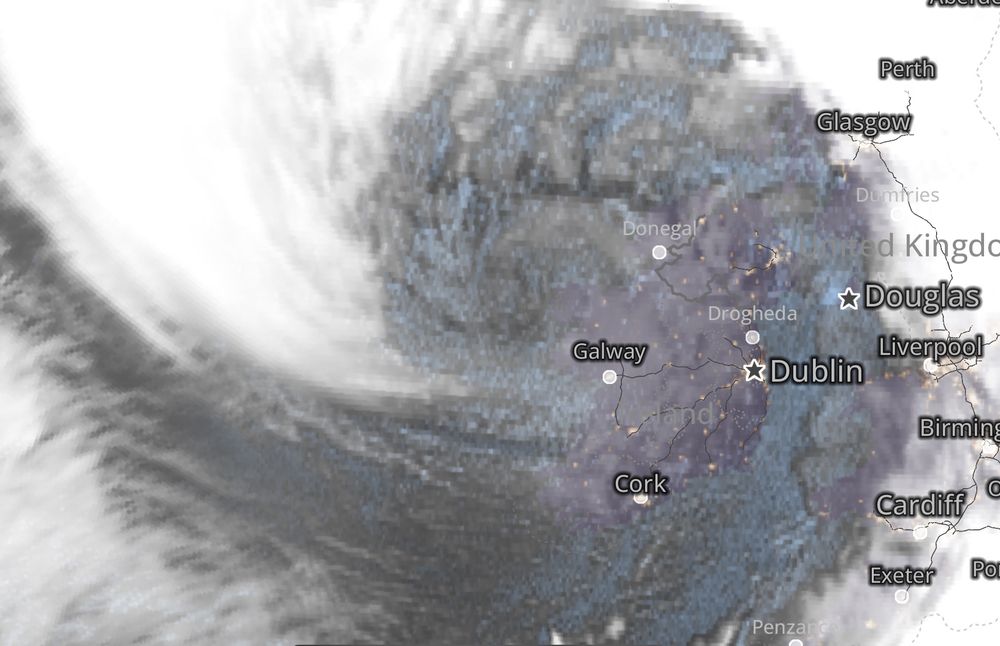
WOW! The sting jet is about to hit Galway! See the pointy cloud? That’s the “stinger” as seen in @myradar.bsky.social!
Shannon Airport has already gusted to 78 mph; Dublin has gusted to 60 mph.
Galway should be ready for winds gusting 90-100 mph over the next few hours. #StormEowyn
Shannon Airport has already gusted to 78 mph; Dublin has gusted to 60 mph.
Galway should be ready for winds gusting 90-100 mph over the next few hours. #StormEowyn
January 24, 2025 at 1:22 PM
Worth stressing that while storm structure, intensity, sat imagery & gust timing/location are all consistent w/ sting-jet descent, we don't know yet if it reached the ground & caused the W Ireland record gusts. The cold conveyor belt might have had a role & is responsible for the gusts over Scotland
The intensity & structure of #StormÉowyn were certainly conducive to sting-jet descent. This satellite image would be consistent with it, as would be the timing and location of the record gust. However, we can't yet say whether the cold conveyor belt also played a role there 1/2


January 24, 2025 at 10:40 AM
The intensity & structure of #StormÉowyn were certainly conducive to sting-jet descent. This satellite image would be consistent with it, as would be the timing and location of the record gust. However, we can't yet say whether the cold conveyor belt also played a role there 1/2
Reposted by Ambrogio Volonté

Storm Bert is set to hit the UK on Saturday, bringing strong winds, snow and rain.
We spoke to Ambrogio Volonté, Senior Research Fellow at @ncas-uk.bsky.social and the University of Reading, about named storms, and found out what has been causing the cold weather.
ncas.ac.uk/scientist-ex...
We spoke to Ambrogio Volonté, Senior Research Fellow at @ncas-uk.bsky.social and the University of Reading, about named storms, and found out what has been causing the cold weather.
ncas.ac.uk/scientist-ex...

Scientist explains Storm Bert and current cold snap - NCAS
Ambrogio Volonté explains what named storms are, and what is causing the current cold snap.
ncas.ac.uk
November 22, 2024 at 5:22 PM
Storm Bert is set to hit the UK on Saturday, bringing strong winds, snow and rain.
We spoke to Ambrogio Volonté, Senior Research Fellow at @ncas-uk.bsky.social and the University of Reading, about named storms, and found out what has been causing the cold weather.
ncas.ac.uk/scientist-ex...
We spoke to Ambrogio Volonté, Senior Research Fellow at @ncas-uk.bsky.social and the University of Reading, about named storms, and found out what has been causing the cold weather.
ncas.ac.uk/scientist-ex...