


Advance Weather
@advanceweather.bsky.social
Forecasting excellence for your tomorrow.
📍Southern Ontario
Website: advanceweather.net
📍Southern Ontario
Website: advanceweather.net
Friday will bring another chilly day to the region, with most areas seeing a mix of sun and cloud. A few flurries will be around in Central Ontario, with some light snow in the Bruce Peninsula.
Some snow remains in the forecast for the foreseeable future.
Some snow remains in the forecast for the foreseeable future.

December 5, 2025 at 3:07 AM
Friday will bring another chilly day to the region, with most areas seeing a mix of sun and cloud. A few flurries will be around in Central Ontario, with some light snow in the Bruce Peninsula.
Some snow remains in the forecast for the foreseeable future.
Some snow remains in the forecast for the foreseeable future.
Wednesday will bring a mix of sun and cloud across the area, with the Bruce Peninsula and portions of Central Ontario seeing flurries and snow squalls.
Some snow will be possible across the area tomorrow evening as an arctic front passes through the region.
Some snow will be possible across the area tomorrow evening as an arctic front passes through the region.

December 3, 2025 at 4:42 AM
Wednesday will bring a mix of sun and cloud across the area, with the Bruce Peninsula and portions of Central Ontario seeing flurries and snow squalls.
Some snow will be possible across the area tomorrow evening as an arctic front passes through the region.
Some snow will be possible across the area tomorrow evening as an arctic front passes through the region.
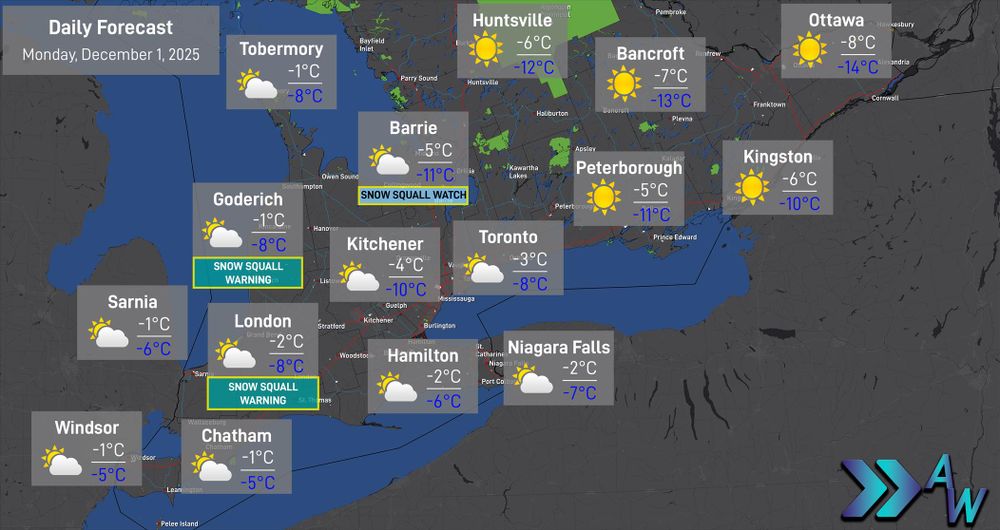
A chilly day is expected across the region tomorrow, with high temperatures below the freezing mark.
Snow Squall Warnings (Yellow level) are in effect tonight. Travel with caution in affected areas. Snowfall of 10 to 20 centimetres is expected.
Snow Squall Warnings (Yellow level) are in effect tonight. Travel with caution in affected areas. Snowfall of 10 to 20 centimetres is expected.
December 1, 2025 at 1:55 AM
A chilly day is expected across the region tomorrow, with high temperatures below the freezing mark.
Snow Squall Warnings (Yellow level) are in effect tonight. Travel with caution in affected areas. Snowfall of 10 to 20 centimetres is expected.
Snow Squall Warnings (Yellow level) are in effect tonight. Travel with caution in affected areas. Snowfall of 10 to 20 centimetres is expected.
4:35 PM ET - Snowfall Warnings (Yellow Level) have been issued for much of Southern Ontario. Environment Canada states 10 to 20 centimetres is likely for many areas.

November 29, 2025 at 9:35 PM
4:35 PM ET - Snowfall Warnings (Yellow Level) have been issued for much of Southern Ontario. Environment Canada states 10 to 20 centimetres is likely for many areas.
#ONwx Accumulating snow is expected across Southern Ontario tomorrow into Sunday.
Snow will likely begin breaking out over Southwestern Ontario during the afternoon to evening hours.
Road conditions will likely become snow covered and slippery quickly.
Snow will likely begin breaking out over Southwestern Ontario during the afternoon to evening hours.
Road conditions will likely become snow covered and slippery quickly.

November 29, 2025 at 3:27 AM
#ONwx Accumulating snow is expected across Southern Ontario tomorrow into Sunday.
Snow will likely begin breaking out over Southwestern Ontario during the afternoon to evening hours.
Road conditions will likely become snow covered and slippery quickly.
Snow will likely begin breaking out over Southwestern Ontario during the afternoon to evening hours.
Road conditions will likely become snow covered and slippery quickly.
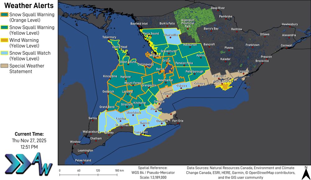
6:37 AM ET - Multiple weather alerts remain in effect this morning (Image 1) including Snow Squall Warnings (Orange and Yellow levels).
Many roads in Midwestern Ontario are snow packed this morning. Snow squalls will continue through the day today before weakening.
#ONwx
Many roads in Midwestern Ontario are snow packed this morning. Snow squalls will continue through the day today before weakening.
#ONwx

November 28, 2025 at 11:37 AM
6:37 AM ET - Multiple weather alerts remain in effect this morning (Image 1) including Snow Squall Warnings (Orange and Yellow levels).
Many roads in Midwestern Ontario are snow packed this morning. Snow squalls will continue through the day today before weakening.
#ONwx
Many roads in Midwestern Ontario are snow packed this morning. Snow squalls will continue through the day today before weakening.
#ONwx
❄️ LOOK AHEAD: More Snow Likely This Weekend
Once the snow squalls wrap up late Friday into early Saturday morning, focus will shift to another system that is expected to impact the region Saturday afternoon into Sunday.
Once the snow squalls wrap up late Friday into early Saturday morning, focus will shift to another system that is expected to impact the region Saturday afternoon into Sunday.

November 28, 2025 at 3:06 AM
❄️ LOOK AHEAD: More Snow Likely This Weekend
Once the snow squalls wrap up late Friday into early Saturday morning, focus will shift to another system that is expected to impact the region Saturday afternoon into Sunday.
Once the snow squalls wrap up late Friday into early Saturday morning, focus will shift to another system that is expected to impact the region Saturday afternoon into Sunday.

Friday will be a chilly day across the region, with flurries for many areas. Snow squalls will continue to shift throughout the day.
Snow Squall Warnings (Orange and Yellow levels) remain in effect this evening.
Snow Squall Warnings (Orange and Yellow levels) remain in effect this evening.

November 28, 2025 at 1:35 AM
Friday will be a chilly day across the region, with flurries for many areas. Snow squalls will continue to shift throughout the day.
Snow Squall Warnings (Orange and Yellow levels) remain in effect this evening.
Snow Squall Warnings (Orange and Yellow levels) remain in effect this evening.
2:47 PM ET - Snow Squall Warning (Yellow Level) now issued for the City of #Hamilton and Oxford-Brant.
Widespread Snow Squall Warnings (Orange and Yellow levels) are now in effect. Snow squall bands will lock in place tonight, when the heaviest snowfall is expected.
Widespread Snow Squall Warnings (Orange and Yellow levels) are now in effect. Snow squall bands will lock in place tonight, when the heaviest snowfall is expected.

November 27, 2025 at 7:48 PM
2:47 PM ET - Snow Squall Warning (Yellow Level) now issued for the City of #Hamilton and Oxford-Brant.
Widespread Snow Squall Warnings (Orange and Yellow levels) are now in effect. Snow squall bands will lock in place tonight, when the heaviest snowfall is expected.
Widespread Snow Squall Warnings (Orange and Yellow levels) are now in effect. Snow squall bands will lock in place tonight, when the heaviest snowfall is expected.
12:05 PM ET - Here is the latest road conditions information from Ontario 511. Many highways in Midwestern Ontario are reported as Partly Snow Covered. Visibility is Poor in many sections.
Data from Ontario 511 / MTO.
#ONwx
Data from Ontario 511 / MTO.
#ONwx

November 27, 2025 at 5:06 PM
12:05 PM ET - Here is the latest road conditions information from Ontario 511. Many highways in Midwestern Ontario are reported as Partly Snow Covered. Visibility is Poor in many sections.
Data from Ontario 511 / MTO.
#ONwx
Data from Ontario 511 / MTO.
#ONwx
10:26 AM ET - Multiple weather alerts remain in effect this morning, including:
Snow Squall Warnings (Orange and Yellow level)
Wind Warning (Yellow level)
Snow Squall Watch (Yellow level)
Special Weather Statement
#ONwx
Snow Squall Warnings (Orange and Yellow level)
Wind Warning (Yellow level)
Snow Squall Watch (Yellow level)
Special Weather Statement
#ONwx

November 27, 2025 at 3:26 PM
10:26 AM ET - Multiple weather alerts remain in effect this morning, including:
Snow Squall Warnings (Orange and Yellow level)
Wind Warning (Yellow level)
Snow Squall Watch (Yellow level)
Special Weather Statement
#ONwx
Snow Squall Warnings (Orange and Yellow level)
Wind Warning (Yellow level)
Snow Squall Watch (Yellow level)
Special Weather Statement
#ONwx
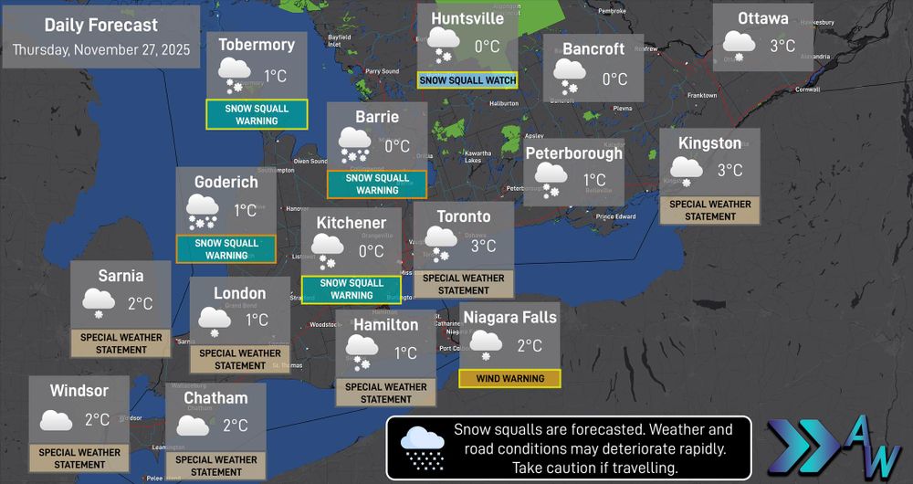
Thursday will bring a cooler day with temperatures just above zero, however the wind will create wind chills below zero across the region.
Flurries are expected for many areas, with snow squalls in the forecast for areas off Lake Huron and Georgian Bay.
Flurries are expected for many areas, with snow squalls in the forecast for areas off Lake Huron and Georgian Bay.
November 27, 2025 at 5:54 AM
Thursday will bring a cooler day with temperatures just above zero, however the wind will create wind chills below zero across the region.
Flurries are expected for many areas, with snow squalls in the forecast for areas off Lake Huron and Georgian Bay.
Flurries are expected for many areas, with snow squalls in the forecast for areas off Lake Huron and Georgian Bay.
11:37 PM ET - Snow Squall Warnings (Orange Level) and Snow Squall Warnings (Yellow Level) are in effect.
Snow Squall Watches (Orange and Yellow Levels) also remain in effect.
For areas in the Snow Squall Warning (Orange Level), Environment Canada states: Travel will be extremely hazardous.
Snow Squall Watches (Orange and Yellow Levels) also remain in effect.
For areas in the Snow Squall Warning (Orange Level), Environment Canada states: Travel will be extremely hazardous.
November 27, 2025 at 4:37 AM
11:37 PM ET - Snow Squall Warnings (Orange Level) and Snow Squall Warnings (Yellow Level) are in effect.
Snow Squall Watches (Orange and Yellow Levels) also remain in effect.
For areas in the Snow Squall Warning (Orange Level), Environment Canada states: Travel will be extremely hazardous.
Snow Squall Watches (Orange and Yellow Levels) also remain in effect.
For areas in the Snow Squall Warning (Orange Level), Environment Canada states: Travel will be extremely hazardous.
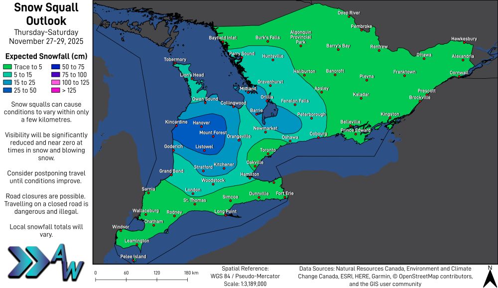
❄️ STORM CENTRE UPDATE: Based on the latest data available, expected snowfall amounts for areas off Georgian Bay have increased.
Our updated forecast includes 25 to 50 centimetres of snow for areas such as Barrie, Midland, Orillia, Port Perry and Lindsay.
#ONwx
Our updated forecast includes 25 to 50 centimetres of snow for areas such as Barrie, Midland, Orillia, Port Perry and Lindsay.
#ONwx


November 27, 2025 at 4:28 AM
❄️ STORM CENTRE UPDATE: Based on the latest data available, expected snowfall amounts for areas off Georgian Bay have increased.
Our updated forecast includes 25 to 50 centimetres of snow for areas such as Barrie, Midland, Orillia, Port Perry and Lindsay.
#ONwx
Our updated forecast includes 25 to 50 centimetres of snow for areas such as Barrie, Midland, Orillia, Port Perry and Lindsay.
#ONwx

#ONwx Wind gusts are increasing across the region as the cold front passes through the area.
Here is some important information about what to do during high winds.
Here is some important information about what to do during high winds.

November 26, 2025 at 4:24 PM
#ONwx Wind gusts are increasing across the region as the cold front passes through the area.
Here is some important information about what to do during high winds.
Here is some important information about what to do during high winds.
9:10 AM ET - Wind Warnings, Special Weather Statements and Snow Squall Watches remain in effect across the region this morning.
Visit the STORM CENTRE for a full forecast update.
#ONwx
Visit the STORM CENTRE for a full forecast update.
#ONwx

November 26, 2025 at 2:11 PM
9:10 AM ET - Wind Warnings, Special Weather Statements and Snow Squall Watches remain in effect across the region this morning.
Visit the STORM CENTRE for a full forecast update.
#ONwx
Visit the STORM CENTRE for a full forecast update.
#ONwx
Wednesday will bring rain showers tracking through the region, along with a sharp change in temperature throughout the day.
Temperatures will reach their high temperatures during the morning and early afternoon before falling with the passage of a cold front.
Temperatures will reach their high temperatures during the morning and early afternoon before falling with the passage of a cold front.

November 26, 2025 at 4:52 AM
Wednesday will bring rain showers tracking through the region, along with a sharp change in temperature throughout the day.
Temperatures will reach their high temperatures during the morning and early afternoon before falling with the passage of a cold front.
Temperatures will reach their high temperatures during the morning and early afternoon before falling with the passage of a cold front.
#ONwx Send Us Your Storm Reports!
Whether you are experiencing a power outage, icy road conditions, drifting snow or just want to tell us that it's snowing, we appreciate it!
Scan the QR code below to submit storm reports, or visit www.advanceweather.net/report-weather.
Whether you are experiencing a power outage, icy road conditions, drifting snow or just want to tell us that it's snowing, we appreciate it!
Scan the QR code below to submit storm reports, or visit www.advanceweather.net/report-weather.

November 26, 2025 at 1:53 AM
#ONwx Send Us Your Storm Reports!
Whether you are experiencing a power outage, icy road conditions, drifting snow or just want to tell us that it's snowing, we appreciate it!
Scan the QR code below to submit storm reports, or visit www.advanceweather.net/report-weather.
Whether you are experiencing a power outage, icy road conditions, drifting snow or just want to tell us that it's snowing, we appreciate it!
Scan the QR code below to submit storm reports, or visit www.advanceweather.net/report-weather.
#ONwx ⚠️ Multi-Day Lake Effect Snow and Strong Winds Expected
Winter will pack a punch the next few days in Southern Ontario, as a cold front will cause temperatures to fall quickly during the day on Wednesday.
Winter will pack a punch the next few days in Southern Ontario, as a cold front will cause temperatures to fall quickly during the day on Wednesday.


November 26, 2025 at 12:15 AM
#ONwx ⚠️ Multi-Day Lake Effect Snow and Strong Winds Expected
Winter will pack a punch the next few days in Southern Ontario, as a cold front will cause temperatures to fall quickly during the day on Wednesday.
Winter will pack a punch the next few days in Southern Ontario, as a cold front will cause temperatures to fall quickly during the day on Wednesday.
#ONwx With strong wind gusts beginning Wednesday and snow squalls beginning early Thursday, the Storm Centre will be activated later tonight with full forecast information.

November 25, 2025 at 11:16 PM
#ONwx With strong wind gusts beginning Wednesday and snow squalls beginning early Thursday, the Storm Centre will be activated later tonight with full forecast information.
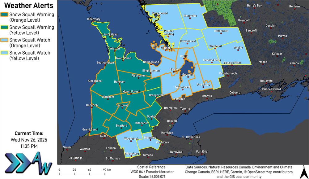
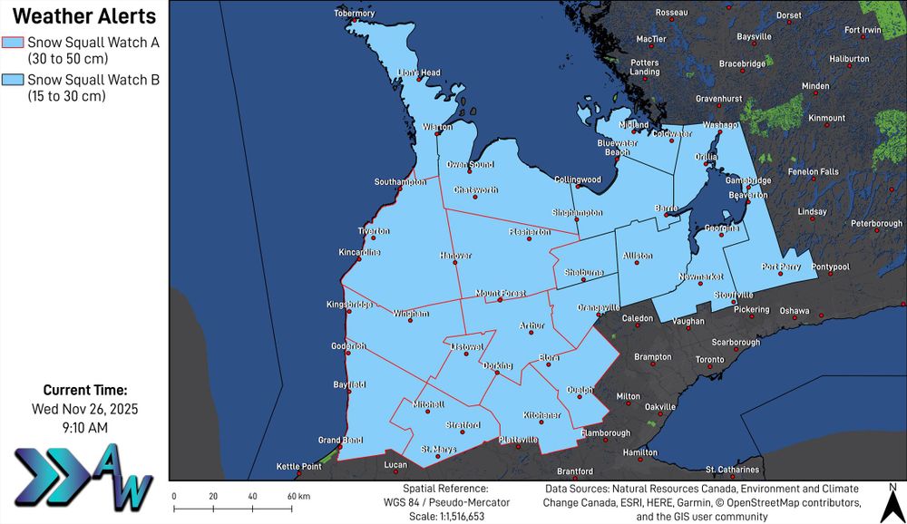
3:22 PM ET - Snow Squall Watch issued for areas off Lake Huron and Georgian Bay.
For Snow Squall Watch A (red outline), 30 to 50 cm of snow is expected. Environment Canada states that some routes may become impassable.
For Snow Squall Watch B (black outline), 15 to 30 cm of snow is expected.
For Snow Squall Watch A (red outline), 30 to 50 cm of snow is expected. Environment Canada states that some routes may become impassable.
For Snow Squall Watch B (black outline), 15 to 30 cm of snow is expected.

November 25, 2025 at 8:22 PM
3:22 PM ET - Snow Squall Watch issued for areas off Lake Huron and Georgian Bay.
For Snow Squall Watch A (red outline), 30 to 50 cm of snow is expected. Environment Canada states that some routes may become impassable.
For Snow Squall Watch B (black outline), 15 to 30 cm of snow is expected.
For Snow Squall Watch A (red outline), 30 to 50 cm of snow is expected. Environment Canada states that some routes may become impassable.
For Snow Squall Watch B (black outline), 15 to 30 cm of snow is expected.
3:13 PM ET - Special Weather Statement B (black outline) issued for Southwestern and Midwestern Ontario, as well as areas along Lake Ontario.
Wind gusts of 70 to 80 km/h are expected.
Special Weather Statement A (red outline) remains in effect for wind gusts of 80 to 90 km/h.
Wind gusts of 70 to 80 km/h are expected.
Special Weather Statement A (red outline) remains in effect for wind gusts of 80 to 90 km/h.

November 25, 2025 at 8:14 PM
3:13 PM ET - Special Weather Statement B (black outline) issued for Southwestern and Midwestern Ontario, as well as areas along Lake Ontario.
Wind gusts of 70 to 80 km/h are expected.
Special Weather Statement A (red outline) remains in effect for wind gusts of 80 to 90 km/h.
Wind gusts of 70 to 80 km/h are expected.
Special Weather Statement A (red outline) remains in effect for wind gusts of 80 to 90 km/h.